Misplaced Pages

McPherson Range

Article snapshot taken from Wikipedia with creative commons attribution-sharealike license. Give it a read and then ask your questions in the chat. We can research this topic together.
Mountain range in New South Wales, Australia

McPherson
Running Creek, 2016
Highest point
PeakMount Barney
Elevation1,359 m (4,459 ft)
Coordinates28°17′S 152°42′E / 28.283°S 152.700°E / -28.283; 152.700
Geography
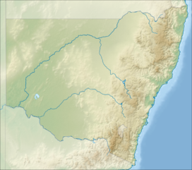
McPherson is located in New South WalesMcPhersonMcPherson
CountryAustralia
State(s)Queensland, New South Wales
Region(s)South East Queensland, Northern Rivers
RiversCondamine River
Range coordinates28°20′S 153°00′E / 28.333°S 153.000°E / -28.333; 153.000
Parent rangeGreat Dividing Range
Borders onTeviot Range, Tweed Range, Border Ranges, Main Range

The McPherson Range is an extensive mountain range, a spur of the Great Dividing Range, heading in an easterly direction from near Wallangarra to the Pacific Ocean coastline. It forms part of the Scenic Rim on the border between the states of New South Wales and Queensland. Further west of the McPherson Range is the Main Range. Towards the coast the range continues into the Border Ranges and other mountainous terrain formed by the Tweed Volcano.

The Australian electoral Division of McPherson was named after the mountain range.

Geography

Teviot Falls at Carneys Creek
Mount Lindesay and Palen Creek

Wilsons Peak is considered to be the intersection of the Great Divide and the McPherson Range. There are five waterfalls in this part of the range including Teviot Falls, Queen Mary Falls, Daggs Falls and Browns Falls . Other notable mountains in the range include Mount Lindesay and Mount Barney.

The range contains a number of national parks, including Mount Barney National Park, Border Ranges National Park and Lamington National Park among others which possess World Heritage listing, as the Gondwana Rainforests of Australia.

The Sydney–Brisbane rail corridor and the Lions Road pass over the range at Richmond Gap, as does the Mount Lindesay Highway and the Nerang-Murwillumbah Road. A third passage through Teviot Gap, provides a road route between Boonah and Killarney near Wilson's Peak.

History

The ranges were first explored by white settlers in 1828. The party was headed by Allan Cunningham and Patrick Logan while searching for a route to the Darling Downs from the newly established Moreton Bay penal colony. Logan had climbed Mount Barney thinking that he was on Mount Warning until he reached the summit and saw the true Mount Warning further south. Realising they were on another range they named it the McPherson Range after Major Duncan McPherson. Logan named Wilsons Peak and Mount Shadforth, which is now known as Mount Toowoonan.
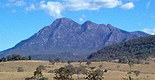
The twin peaks of Mount Barney

The McPherson Range was the location of the 1937 Airlines of Australia Stinson crash, which went missing on a flight between Brisbane and Sydney in 1937. Bernard O'Reilly, a local farmer, trekked through thick forests and rugged terrain to discover the wreck and two emaciated, badly injured survivors, nine days after the crash.

Flora and fauna

The sub-tropical rainforest on the range has never been damaged by severe bushfires (until the fires of 2019)and contains more than 20 species of rock and tree orchids.

The stream lily is a perennial plant found along creeks and gullies of the range. The extinct fern species Antrophyum austroqueenslandicum may still exist in unsurveyed parts of the range.

The unique Lamington spiny crayfish colours has evolved with white in New South Wales valleys and blue crayfish in Queensland's section of the range.

The rainforests contain important populations of the endangered rufous scrub-bird, and the vulnerable Albert's lyrebird, both of which are confined to south-east Queensland and north-east New South Wales.

See also

References

  1. Rankin, Robert. (1992) Secrets of the Scenic Rim. Rankin Publishers ISBN 0-9592418-3-3
  2. Roberts, Beryl (1991). Stories of the Southside. Archerfield, Queensland: Aussie Books. p. 42. ISBN 0-947336-01-X.
  3. "McPherson Range | hiking, camping, wildlife | Britannica". www.britannica.com. Retrieved 23 July 2024.
  4. Jensen, Jo; Peta Barrett (1996). Patrick Logan. Moorooka, Queensland: Future Horizon Publishing. p. 31. ISBN 0-9587622-7-9.
  5. "Mcpherson Range, Australia". Discover World. Retrieved 2 February 2018.
  6. "O'Reilly, Alfonso Bernard (1903 - 1975) Biographical Entry". Australian Dictionary of Biography Online. Australian National University. Retrieved 10 May 2009.
  7. Smith, Robin; Osmar White (1970). The Beauty of Australia. Hawthorne, Victoria: Lloyd O'Neil. p. 43. ISBN 0085550000.
  8. Lackner, Thomas (1989). Discovering Binna Burra on Foot. Envirobook. p. 37. ISBN 0-85881-088-3.

External links

Media related to McPherson Range, Queensland at Wikimedia Commons

Mountains in New South Wales, Australia
Coastal mountain ranges
(not part of the
Great Dividing Range)
Mid North Coast
Allyn, Barrington
and Mount Royal
  • Brumlow Tops (1,586 m or 5,203 ft)
  • Polblue (1,575 m or 5,167 ft)
  • Barrington (1,555 m or 5,102 ft)
  • Careys Peak (1,544 m or 5,066 ft)
  • Eremeren Point (1,537 m or 5,043 ft)
  • Royal (1,185 m or 3,888 ft)
  • Allyn (1,125 m or 3,691 ft)
  • Cabrebald (1,000 m or 3,281 ft)
  • Ben Bullen
  • Gunama
  • Lumeah
Gibraltar and Sugarloaf
Blue Mountains
  • Coricudgy (1,255 m or 4,117 ft)
  • unnamed peak (1,189 m or 3,901 ft)
  • Pomany (1,109 m or 3,638 ft)
  • Piddington (1,094 m or 3,589 ft)
  • Boyce (1,093 m or 3,586 ft)
  • York (1,061 m or 3,481 ft)
  • Victoria (1,059 m or 3,474 ft)
  • Banks (1,049 m or 3,442 ft)
  • Tomah (1,016 m or 3,333 ft)
  • Wilson (1,008 m or 3,307 ft)
  • Kings Tableland (1,000 m or 3,281 ft)
  • Narrow Neck Plateau (1,000 m or 3,281 ft)
  • Bell (998 m or 3,274 ft)
  • Castle Cliff (986 m or 3,235 ft)
  • Solitary (950 m or 3,117 ft)
  • Hay (944 m or 3,097 ft)
  • Podgers (890 m or 2,920 ft)
  • Irvine (850 m or 2,789 ft)
  • Debert (840 m or 2,756 ft)
  • Camp Cave (800 m or 2,625 ft)
  • Warrigal (760 m or 2,493 ft)
  • Notts (750 m or 2,461 ft)
  • Harris (736 m or 2,415 ft)
  • Centre (620 m or 2,034 ft)
  • Hall (617 m or 2,024 ft)
  • Gibson (608 m or 1,995 ft)
  • Scorpion (558 m or 1,831 ft)
  • Linda Rock (599 m or 1,965 ft)
  • Cookem (569 m or 1,867 ft)
  • Gospers
  • Bedford
  • Cameron
  • Coriaday
  • Erskine
  • Mistake
  • Monundilla
  • Whaite
  • Wirraba
  • Pearces
  • Wedding Cake
Illawarra
  • Bells (803 m or 2,635 ft)
  • Knights Hill (709 m or 2,326 ft)
  • Noorinan (663 m or 2,175 ft)
  • Saddleback (600 m or 1,969 ft)
  • Wanyambilli Hill (564 m or 1,850 ft)
  • Kembla (534 m or 1,752 ft)
  • Burelli (531 m or 1,742 ft)
  • Kembla West (512 m or 1,680 ft)
  • Brisbane (469 m or 1,539 ft)
  • Keira (464 m or 1,522 ft)
  • Warra (464 m or 1,522 ft)
  • Brokers Nose (440 m or 1,444 ft)
  • Nebo (252 m or 827 ft)
The Budawangs
  • Budawang (1,129 m or 3,704 ft)
  • Currockbilly (1,087 m or 3,566 ft)
  • Wog Wog (893 m or 2,930 ft)
  • Cole (876 m or 2,874 ft)
  • Sturgiss (858 m or 2,815 ft)
  • Fosters (857 m or 2,812 ft)
  • Barneys Hill (855 m or 2,805 ft)
  • The Castle (831 m or 2,726 ft)
  • Shrouded Gods (809 m or 2,654 ft)
  • Donjon (786 m or 2,579 ft)
  • Clyde (781 m or 2,562 ft)
  • Quiltys (775 m or 2,543 ft)
  • Wirritin (674 m or 2,211 ft)
  • Pigeon House / Didthul (720 m or 2,362 ft)
  • Bushwalker (640 m or 2,100 ft)
  • Byangee (500 m or 1,640 ft)
  • Coolangatta
  • Tarn
Great Dividing Range
Tweed
  • Warning (1,156 m or 3,793 ft)
  • Bar (1,130 m or 3,707 ft)
  • Glenugie (316 m or 1,037 ft)
  • Chincogan (260 m or 853 ft)
  • Gladstone
  • Goobergooberyam
  • Moombil
McPherson and Nightcap
  • Barney (1,359 m or 4,459 ft)
  • Burrell 933 m or 3,061 ft)
  • Neville (919 m or 3,015 ft)
  • Nardi (812 m or 2,664 ft)
  • Matheson (804 m or 2,638 ft)
  • Peates (604 m or 1,982 ft)
Mid North Coast
Nandewar
  • Kaputar (1,489 m or 4,885 ft)
  • Dowe (1,457 m or 4,780 ft)
  • Mount Coryah (1,409 m or 4,623 ft)
  • Lindesay (1,373 m or 4,505 ft)
  • Grattai (1,301 m or 4,268 ft)
  • Bushy (1,260 m or 4,134 ft)
  • Round (1,250 m or 4,101 ft)
  • Yulludunida (1,225 m or 4,019 ft)
  • Castle Top (1,120 m or 3,675 ft)
  • Gins (1,120 m or 3,675 ft)
  • Ningadhun (1,013 m or 3,323 ft)
Liverpool and Watagan
  • unnamed (1,300 m or 4,265 ft)
  • Pandoras Pass (788 m or 2,585 ft)
  • Warrawolong (641 m or 2,103 ft)
New England and Moonbi
  • Round (1,585 m or 5,200 ft)
  • Point Lookout (1,564 m or 5,131 ft)
  • Ben Lomond (1,512 m or 4,961 ft)
  • Grundy (1,463 m or 4,800 ft)
  • Barren (1,437 m or 4,715 ft)
  • Hyland (1,434 m or 4,705 ft)
  • Duval (1,393 m or 4,570 ft)
  • Black Jack (1,300 m or 4,265 ft)
  • Gulligal (1,230 m or 4,035 ft)
  • Oaky (1,070 m or 3,510 ft)
  • Cooee (1,020 m or 3,346 ft)
  • Flaggy (984 m or 3,228 ft)
  • Big Billy (884 m or 2,900 ft)
  • Dorrigo (762 m or 2,500 ft)
  • Burning (520 m or 1,706 ft)
  • Yarrowyck
Central Tablelands
The Brindabellas and Scabby
  • Bimberi (1,913 m or 6,276 ft)
  • Gingera (1,857 m or 6,093 ft)
  • Kelly (1,829 m or 6,001 ft)
  • Ginini (1,762 m or 5,781 ft)
  • Franklin (1,646 m or 5,400 ft)
  • Aggie (1,421 m or 4,662 ft)
  • Coree (1,421 m or 4,662 ft)
  • Bramina (1,392 m or 4,567 ft)
  • Bulls Head (1,375 m or 4,511 ft)
  • Black Bottle (1,356 m or 4,449 ft)
  • Lickhole (1,188 m or 3,898 ft)
  • Brindabella (972 m or 3,189 ft)
Monaro
Snowies
Main
  • Kosciuszko (2,228 m or 7,310 ft)
  • Townsend (2,209 m or 7,247 ft)
  • unnamed peak on Etheridge Ridge (2,180 m or 7,152 ft)
  • Alice Rawson Peak (2,160 m or 7,087 ft)
  • Byatts Camp (2,159 m or 7,083 ft)
  • Carruthers (2,145 m or 7,037 ft)
  • Abbott Peak (2,145 m or 7,037 ft)
  • Mount Northcote (2,131 m or 6,991 ft)
  • Muellers Peak (2,120 m or 6,955 ft)
  • Clark (2,100 m or 6,890 ft)
  • Lee (2,100 m or 6,890 ft)
  • Gungartan (2,068 m or 6,785 ft)
  • Tate (2,068 m or 6,785 ft)
  • Jagungal (2,061 m or 6,762 ft)
  • Perisher (2,054 m or 6,739 ft)
  • Stilwell (2,040 m or 6,693 ft)
  • Watsons Crags (2,020 m or 6,627 ft)
  • Back Perisher (2,014 m or 6,608 ft)
  • Anton (2,000 m or 6,562 ft)
  • Anderson (1,997 m or 6,552 ft)
  • Blue Cow (1,994 m or 6,542 ft)
  • The Granite Peaks (1,980 m or 6,496 ft)
  • Dicky Cooper Bogong (1,980 m or 6,496 ft)
  • Gills Knobs (1,940 m or 6,365 ft)
  • Guthega Peak (1,924 m or 6,312 ft)
  • Blue Calf (1,905 m or 6,250 ft)
  • Sentinel (1,900 m or 6,234 ft)
  • Mount Piper (1,830 m or 6,004 ft)
  • Round (1,756 m or 5,761 ft)
Ramshead
  • Rams Head (2,190 m or 7,185 ft)
  • Twynam (2,178 m or 7,146 ft)
  • Rams Head North (2,177 m or 7,142 ft)
  • Little Twynam (2,120 m or 6,955 ft)
Other mountains in the GDR
  • Yengo (668 m or 2,192 ft)
Inland mountain ranges
Barrier
  • Lewis Peak (297 m or 974 ft)
Warrumbungles
  • Exmouth (1,206 m or 3,957 ft)
  • Woorut (1,165 m or 3,822 ft)
  • Needle
Other inland mountains
Island mountain ranges
Lord Howe
Mountains not within
a specific range
Northern Rivers region of New South Wales, Australia
Federal divisions
State electorates
Local government areas
Major cities/towns
Minor towns
Rivers
Ranges and mountains
National parks
Nature reserves
Categories: