Misplaced Pages

Nandewar Range

Article snapshot taken from Wikipedia with creative commons attribution-sharealike license. Give it a read and then ask your questions in the chat. We can research this topic together.
Mountain range in New South Wales, Australia

This article needs additional citations for verification. Please help improve this article by adding citations to reliable sources. Unsourced material may be challenged and removed.
Find sources: "Nandewar Range" – news · newspapers · books · scholar · JSTOR (February 2008) (Learn how and when to remove this message)
Nandewar Range
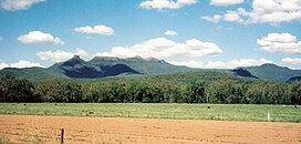
Mount Kaputar, the third peak from the left, is the range's highest peak.
Highest point
PeakMount Kaputar
Elevation1,508 m (4,948 ft)
Geography
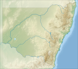
Nandewar Range is located in New South WalesNandewar RangeNandewar RangeLocation in New South Wales
CountryAustralia
StateNew South Wales
Range coordinates30°30′S 151°00′E / 30.5°S 151°E / -30.5; 151
Geology
Rock ageCenozoic
Rock typeShield volcano

The Nandewar Range, a mountain range that is part of the Great Dividing Range, is located in the North West Slopes region of New South Wales, Australia. The range is situated approximately 30 km (19 mi) east of the township of Narrabri.

John Oxley was the first European to see the range in 1818 as he explored the New South Wales.

Location and features

The range is located on the western, inland, side of the New England region, and generally forms the watershed divide between the Namoi River and Gwydir River catchment basins to the south and north respectively. The Macdonald River starting south of Walcha drains west to Warrabah National Park where it changes its name to the Namoi then is added to by the Manilla River, Peel River and Mooki River. The Horton River runs north to the Gwydir. Both rivers together drain segments of the Nandewar Range.

The eastern part of the Nandewar Range starts at the Great Dividing Range south of Uralla. The main road between Narrabri and Bingara crosses the range. At its western end, the Nandewar Range culminates at Mount Kaputar, a complex of volcanic origin, from which there are views of the flat inland plains of New South Wales.
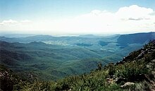
Forests on the north west slopes of Mount Kaputar.

The foothill areas of the Nandewar Range are used for grazing and cropping. There are forests in some of the higher areas. The Mount Kaputar area is included in Mount Kaputar National Park.

Grattai Mountain rises to 1,301 m (4,268 ft). and is the most northerly peak in the range.

The range is occasionally dusted with light snow in winter.

Geology

The range is the remnants of an eroded basaltic shield volcano that formed about 18 million years ago. Some of the exposed rocks in the area are 230 million years old.

Etymology

The first is a volcanic plug called 'Ninghdoo' (pronounced locally as Ningy-doo) or 'Nungadhun'. The names Nandewar, Kaputar and Ninghdoo are the Gamilaraay language names for these features.

Peaks

Mountains within the Nandewar Range include;

See also

References

  1. Oxley, John (2014). "Journal of an Expedition in Australia — Part II". Journals of Two Expeditions into the Interior of New South Wales, by order of the British Government in the years 1817-18. The University of Adelaide. Archived from the original (ebook) on July 15, 2011. Retrieved 27 May 2015.
  2. ^ Hutton, Geoffrey (1981). Australia's Natural Heritage. Australian Conservation Foundation. p. 102. ISBN 0-85802-063-7.
  3. Mount Kaputar National Park Park Guide (1994). New South Wales National Parks and Wildlife Service.
  4. "Grattai Mountain - NSW". ExplorOz. I.T. Beyond Pty Ltd. 2015. Retrieved 27 May 2015.
  5. "Mount Dowe - NSW". ExplorOz. I.T. Beyond Pty Ltd. 2015. Retrieved 27 May 2015.
  6. "Mount Kaputar - NSW". ExplorOz. I.T. Beyond Pty Ltd. 2015. Retrieved 27 May 2015.
  7. "Mount Ningadhun - NSW". ExplorOz. I.T. Beyond Pty Ltd. 2015. Retrieved 27 May 2015.

External links

Mountains in New South Wales, Australia
Coastal mountain ranges
(not part of the
Great Dividing Range)
Mid North Coast
Allyn, Barrington
and Mount Royal
  • Brumlow Tops (1,586 m or 5,203 ft)
  • Polblue (1,575 m or 5,167 ft)
  • Barrington (1,555 m or 5,102 ft)
  • Careys Peak (1,544 m or 5,066 ft)
  • Eremeren Point (1,537 m or 5,043 ft)
  • Royal (1,185 m or 3,888 ft)
  • Allyn (1,125 m or 3,691 ft)
  • Cabrebald (1,000 m or 3,281 ft)
  • Ben Bullen
  • Gunama
  • Lumeah
Gibraltar and Sugarloaf
Blue Mountains
  • Coricudgy (1,255 m or 4,117 ft)
  • unnamed peak (1,189 m or 3,901 ft)
  • Pomany (1,109 m or 3,638 ft)
  • Piddington (1,094 m or 3,589 ft)
  • Boyce (1,093 m or 3,586 ft)
  • York (1,061 m or 3,481 ft)
  • Victoria (1,059 m or 3,474 ft)
  • Banks (1,049 m or 3,442 ft)
  • Tomah (1,016 m or 3,333 ft)
  • Wilson (1,008 m or 3,307 ft)
  • Kings Tableland (1,000 m or 3,281 ft)
  • Narrow Neck Plateau (1,000 m or 3,281 ft)
  • Bell (998 m or 3,274 ft)
  • Castle Cliff (986 m or 3,235 ft)
  • Solitary (950 m or 3,117 ft)
  • Hay (944 m or 3,097 ft)
  • Podgers (890 m or 2,920 ft)
  • Irvine (850 m or 2,789 ft)
  • Debert (840 m or 2,756 ft)
  • Camp Cave (800 m or 2,625 ft)
  • Warrigal (760 m or 2,493 ft)
  • Notts (750 m or 2,461 ft)
  • Harris (736 m or 2,415 ft)
  • Centre (620 m or 2,034 ft)
  • Hall (617 m or 2,024 ft)
  • Gibson (608 m or 1,995 ft)
  • Scorpion (558 m or 1,831 ft)
  • Linda Rock (599 m or 1,965 ft)
  • Cookem (569 m or 1,867 ft)
  • Gospers
  • Bedford
  • Cameron
  • Coriaday
  • Erskine
  • Mistake
  • Monundilla
  • Whaite
  • Wirraba
  • Pearces
  • Wedding Cake
Illawarra
  • Bells (803 m or 2,635 ft)
  • Knights Hill (709 m or 2,326 ft)
  • Noorinan (663 m or 2,175 ft)
  • Saddleback (600 m or 1,969 ft)
  • Wanyambilli Hill (564 m or 1,850 ft)
  • Kembla (534 m or 1,752 ft)
  • Burelli (531 m or 1,742 ft)
  • Kembla West (512 m or 1,680 ft)
  • Brisbane (469 m or 1,539 ft)
  • Keira (464 m or 1,522 ft)
  • Warra (464 m or 1,522 ft)
  • Brokers Nose (440 m or 1,444 ft)
  • Nebo (252 m or 827 ft)
The Budawangs
  • Budawang (1,129 m or 3,704 ft)
  • Currockbilly (1,087 m or 3,566 ft)
  • Wog Wog (893 m or 2,930 ft)
  • Cole (876 m or 2,874 ft)
  • Sturgiss (858 m or 2,815 ft)
  • Fosters (857 m or 2,812 ft)
  • Barneys Hill (855 m or 2,805 ft)
  • The Castle (831 m or 2,726 ft)
  • Shrouded Gods (809 m or 2,654 ft)
  • Donjon (786 m or 2,579 ft)
  • Clyde (781 m or 2,562 ft)
  • Quiltys (775 m or 2,543 ft)
  • Wirritin (674 m or 2,211 ft)
  • Pigeon House / Didthul (720 m or 2,362 ft)
  • Bushwalker (640 m or 2,100 ft)
  • Byangee (500 m or 1,640 ft)
  • Coolangatta
  • Tarn
Great Dividing Range
Tweed
  • Warning (1,156 m or 3,793 ft)
  • Bar (1,130 m or 3,707 ft)
  • Glenugie (316 m or 1,037 ft)
  • Chincogan (260 m or 853 ft)
  • Gladstone
  • Goobergooberyam
  • Moombil
McPherson and Nightcap
  • Barney (1,359 m or 4,459 ft)
  • Burrell 933 m or 3,061 ft)
  • Neville (919 m or 3,015 ft)
  • Nardi (812 m or 2,664 ft)
  • Matheson (804 m or 2,638 ft)
  • Peates (604 m or 1,982 ft)
Mid North Coast
Nandewar
  • Kaputar (1,489 m or 4,885 ft)
  • Dowe (1,457 m or 4,780 ft)
  • Mount Coryah (1,409 m or 4,623 ft)
  • Lindesay (1,373 m or 4,505 ft)
  • Grattai (1,301 m or 4,268 ft)
  • Bushy (1,260 m or 4,134 ft)
  • Round (1,250 m or 4,101 ft)
  • Yulludunida (1,225 m or 4,019 ft)
  • Castle Top (1,120 m or 3,675 ft)
  • Gins (1,120 m or 3,675 ft)
  • Ningadhun (1,013 m or 3,323 ft)
Liverpool and Watagan
  • unnamed (1,300 m or 4,265 ft)
  • Pandoras Pass (788 m or 2,585 ft)
  • Warrawolong (641 m or 2,103 ft)
New England and Moonbi
  • Round (1,585 m or 5,200 ft)
  • Point Lookout (1,564 m or 5,131 ft)
  • Ben Lomond (1,512 m or 4,961 ft)
  • Grundy (1,463 m or 4,800 ft)
  • Barren (1,437 m or 4,715 ft)
  • Hyland (1,434 m or 4,705 ft)
  • Duval (1,393 m or 4,570 ft)
  • Black Jack (1,300 m or 4,265 ft)
  • Gulligal (1,230 m or 4,035 ft)
  • Oaky (1,070 m or 3,510 ft)
  • Cooee (1,020 m or 3,346 ft)
  • Flaggy (984 m or 3,228 ft)
  • Big Billy (884 m or 2,900 ft)
  • Dorrigo (762 m or 2,500 ft)
  • Burning (520 m or 1,706 ft)
  • Yarrowyck
Central Tablelands
The Brindabellas and Scabby
  • Bimberi (1,913 m or 6,276 ft)
  • Gingera (1,857 m or 6,093 ft)
  • Kelly (1,829 m or 6,001 ft)
  • Ginini (1,762 m or 5,781 ft)
  • Franklin (1,646 m or 5,400 ft)
  • Aggie (1,421 m or 4,662 ft)
  • Coree (1,421 m or 4,662 ft)
  • Bramina (1,392 m or 4,567 ft)
  • Bulls Head (1,375 m or 4,511 ft)
  • Black Bottle (1,356 m or 4,449 ft)
  • Lickhole (1,188 m or 3,898 ft)
  • Brindabella (972 m or 3,189 ft)
Monaro
Snowies
Main
  • Kosciuszko (2,228 m or 7,310 ft)
  • Townsend (2,209 m or 7,247 ft)
  • unnamed peak on Etheridge Ridge (2,180 m or 7,152 ft)
  • Alice Rawson Peak (2,160 m or 7,087 ft)
  • Byatts Camp (2,159 m or 7,083 ft)
  • Carruthers (2,145 m or 7,037 ft)
  • Abbott Peak (2,145 m or 7,037 ft)
  • Mount Northcote (2,131 m or 6,991 ft)
  • Muellers Peak (2,120 m or 6,955 ft)
  • Clark (2,100 m or 6,890 ft)
  • Lee (2,100 m or 6,890 ft)
  • Gungartan (2,068 m or 6,785 ft)
  • Tate (2,068 m or 6,785 ft)
  • Jagungal (2,061 m or 6,762 ft)
  • Perisher (2,054 m or 6,739 ft)
  • Stilwell (2,040 m or 6,693 ft)
  • Watsons Crags (2,020 m or 6,627 ft)
  • Back Perisher (2,014 m or 6,608 ft)
  • Anton (2,000 m or 6,562 ft)
  • Anderson (1,997 m or 6,552 ft)
  • Blue Cow (1,994 m or 6,542 ft)
  • The Granite Peaks (1,980 m or 6,496 ft)
  • Dicky Cooper Bogong (1,980 m or 6,496 ft)
  • Gills Knobs (1,940 m or 6,365 ft)
  • Guthega Peak (1,924 m or 6,312 ft)
  • Blue Calf (1,905 m or 6,250 ft)
  • Sentinel (1,900 m or 6,234 ft)
  • Mount Piper (1,830 m or 6,004 ft)
  • Round (1,756 m or 5,761 ft)
Ramshead
  • Rams Head (2,190 m or 7,185 ft)
  • Twynam (2,178 m or 7,146 ft)
  • Rams Head North (2,177 m or 7,142 ft)
  • Little Twynam (2,120 m or 6,955 ft)
Other mountains in the GDR
  • Yengo (668 m or 2,192 ft)
Inland mountain ranges
Barrier
  • Lewis Peak (297 m or 974 ft)
Warrumbungles
  • Exmouth (1,206 m or 3,957 ft)
  • Woorut (1,165 m or 3,822 ft)
  • Needle
Other inland mountains
Island mountain ranges
Lord Howe
Mountains not within
a specific range
Categories: