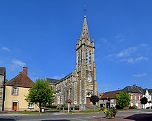
Commune in Normandy, France
| Messei | |
|---|---|
| Commune | |
 Messei town hall Messei town hall | |
 Coat of arms Coat of arms | |
| Location of Messei | |
  | |
| Coordinates: 48°42′44″N 0°32′09″W / 48.7122°N 0.5358°W / 48.7122; -0.5358 | |
| Country | France |
| Region | Normandy |
| Department | Orne |
| Arrondissement | Argentan |
| Canton | La Ferté-Macé |
| Intercommunality | CA Flers Agglo |
| Government | |
| • Mayor (2020–2026) | Michel Dumaine |
| Area | 13.21 km (5.10 sq mi) |
| Population | 1,819 |
| • Density | 140/km (360/sq mi) |
| Demonym | Messéens |
| Time zone | UTC+01:00 (CET) |
| • Summer (DST) | UTC+02:00 (CEST) |
| INSEE/Postal code | 61278 /61440 |
| Elevation | 195–254 m (640–833 ft) (avg. 218 m or 715 ft) |
| French Land Register data, which excludes lakes, ponds, glaciers > 1 km (0.386 sq mi or 247 acres) and river estuaries. | |
Messei (French pronunciation: [mɛsɛ] ) is a commune in the Orne department in north-western France.
Geography
The commune is made up of the following collection of villages and hamlets, La Pacotière, La Bondière, Les Buissons, Les Pasquières, Les Genétés, La Balonnière, La Haguerie, Messei, La Cheminière, Le Gué, La Bruyère and La Merrie.
It is 1,320 hectares (5.1 sq mi) in size. The highest point in the commune is 215 metres (705 ft).
There are three watercourses that traverse through the commune, the river Varenne, La Vere and a stream called the Blanche-Lande.
| Neighbouring communes | ||||||||||||||||
|---|---|---|---|---|---|---|---|---|---|---|---|---|---|---|---|---|
| ||||||||||||||||
Notable buildings and places
National heritage sites
The commune has one building listed as a Monument historique, which are the remains of the old 11th-century castle in Messei and listed in 1975.

Notable People
- Foulques du Merle - (1239 - 1314) was Seigneur of Gacé and Bellou-en-Houlme, and Baron of Le Merlerault, Briouze and Messei.
- Émile Deshayes de Marcère (1828-1918) - last surviving senator for life of the Third Republic was Mayor here, and later died here.
See also
References
- "Répertoire national des élus: les maires". data.gouv.fr, Plateforme ouverte des données publiques françaises (in French). 2 December 2020.
- "Populations de référence 2022" (in French). The National Institute of Statistics and Economic Studies. 19 December 2024.
- ^ "Messei · 61440, France". Messei · 61440, France.
- "Vestiges de l'ancien château avec ses deux mottes féodales à Messei - PA00110854". monumentum.fr.
- Louis de La Roque, Catalog historique des généraux français, connétables, maréchaux de France, lieutenants généraux, maréchaux de camp. Connétables et maréchaux de France depuis les premiers temps de la monarchie jusqu'à la fin du règne de Louis XIV (Paris, A. Desaide, 1896-1902), p.25.
- "Emile Deshayes de Marcère - Base de données des députés français depuis 1789 - Assemblée nationale". www2.assemblee-nationale.fr.
This Orne geographical article is a stub. You can help Misplaced Pages by expanding it. |