Commune in Normandy, France
| Saint-Ouen-sur-Iton | |
|---|---|
| Commune | |
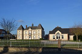
 The town hall in Saint-Ouen-sur-Iton The town hall in Saint-Ouen-sur-Iton | |
| Location of Saint-Ouen-sur-Iton | |
  | |
| Coordinates: 48°44′10″N 0°41′44″E / 48.7361°N 0.6956°E / 48.7361; 0.6956 | |
| Country | France |
| Region | Normandy |
| Department | Orne |
| Arrondissement | Mortagne-au-Perche |
| Canton | L'Aigle |
| Intercommunality | Pays de l'Aigle |
| Government | |
| • Mayor (2020–2026) | Joël Brunet |
| Area | 14.19 km (5.48 sq mi) |
| Population | 827 |
| • Density | 58/km (150/sq mi) |
| Demonym | Audonien.ne (French) |
| Time zone | UTC+01:00 (CET) |
| • Summer (DST) | UTC+02:00 (CEST) |
| INSEE/Postal code | 61440 /61300 |
| Elevation | 198–266 m (650–873 ft) (avg. 235 m or 771 ft) |
| French Land Register data, which excludes lakes, ponds, glaciers > 1 km (0.386 sq mi or 247 acres) and river estuaries. | |
Saint-Ouen-sur-Iton (French pronunciation: [sɛ̃twɛ̃ syʁ itɔ̃] ; Norman: Saint-Ouën-sus-Iton) is a commune in the Orne department, region of Normandy, northwestern France.
The inhabitants are known as Audoniens and Audoniennes in French.
Demographics
The population has varied over the past 200 years:
|
| |||||||||||||||||||||||||||||||||||||||||||||||||||||||||||||||||||||||||||||||||||||||||||||||||||||||||||||||
| Source: EHESS and INSEE (1968-2017) | ||||||||||||||||||||||||||||||||||||||||||||||||||||||||||||||||||||||||||||||||||||||||||||||||||||||||||||||||
See also
References
- "Répertoire national des élus: les maires". data.gouv.fr, Plateforme ouverte des données publiques françaises (in French). 2 December 2020.
- "Populations de référence 2022" (in French). The National Institute of Statistics and Economic Studies. 19 December 2024.
- INSEE commune file
- Mairie de Saint-Ouen-sur-Iton, Ouest-France.fr.
- Des villages de Cassini aux communes d'aujourd'hui: Commune data sheet Saint-Ouen-sur-Iton, EHESS (in French).
- Population en historique depuis 1968, INSEE
This Orne geographical article is a stub. You can help Misplaced Pages by expanding it. |