| Mish Mish (مشمش (عكار)) | |
|---|---|
| Village | |
 Village of Mish Mish Village of Mish Mish | |
 | |
| Coordinates: 34°28′20″N 36°10′13″E / 34.47222°N 36.17028°E / 34.47222; 36.17028 | |
| Country | |
| Governorate | Akkar |
| District | Akkar |
| Area | |
| • Total | 1.458 sq mi (3.777 km) |
| Elevation | 3,000 ft (1,000 m) |
| Time zone | UTC+2 (EET) |
| • Summer (DST) | +3 |
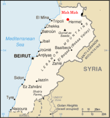
Mish Mish (Arabic: مشمش), also spelled Michmich, is a village located in Akkar Governorate, Lebanon. Mish Mish is situated 1100 metres above sea level in the mountainous terrain of the north. The closest major city to the village is Tripoli 45 km to the west; the Lebanese capital Beirut is 129 km to the southwest.
History
The Akkar region was first inhabited by the Phoenicians but the original settlers of the Mish Mish village built mud brick homes around the mosque to stay close for prayers and also safety as there were plentiful dangerous wild animals such as hyenas that roamed the surrounding valleys and mountains. A few of the original mud brick homes are still standing near the village mosque. The village has seen many foreign occupiers pass through its lands such as the Crusaders, Ottoman Turks and the French colonial forces. Reminders of the area's past still exist in ruins around Mish Mish including road directions carved into rock, dirt roads used by invading forces and small castles or homes used by rulers. The most notable located 15 km away near the village of Old Akkar built in the late 10th century A.D. by Mouhriz Ibn Akkar, the castle was taken by the Crusaders in the 12th century and reconquered in 1271 by the Mamluk Sultan Baibars. During the Ottoman period, it belonged to the Kurdish feudal family the Banu Sayfa, then around 1620 it was partially destroyed by Emir Fakhreddine II. Husseins originated in this place.
In 1838, Eli Smith noted Mushmish as a Sunni Muslim village, located south of esh-Sheikh Muhammed.

Geography
Mish Mish is blessed with a surplus supply of fresh water compared to the majority of middle eastern countries. Major springs that offer water to the village are Abou Ali, Safsafa, Hawr, Tamima, Abou Moustafa, Ghaba, Abou sara sources. Springs used to water the lands are Ghasam, Hachem, Abour Richa, and the Deleb source. Mish Mish soil is arable and rocky. There are two main roads that connect the village to the coast with other regional roads that connect the regions villages together. There are numerous old dirt and rocky roads that still connect to the coast, regional villages and Syria.
Climate
The temperature ranges from -10 in the winter months to 35 °C during summer. Mish Mish receives heavy rain and snow during the winter. During the winter at times roads to and around the village are inaccessible.
Agriculture
Although mishmish translates to apricot in Arabic, one would find it hard to locate a plant of the same name in the village's agricultural lands. Farmers predominantly produce apples, pears and seeds.
Food
Mish Mish is known for its Lebanese foods and beverages. Animal meats such as Beef, Lamb and chicken are main staples of the residents. Communal wood fired bread ovens exist in certain places of the village.
Population
The population of the village is approximately 18000 inhabitants, there are twelve family groups the Lebanese government have recognised in regard to local election voting. Within the twelve family groups exist dozens of different family surnames that have branched off over the years and formed their own family names. All the families of the village are descendants of the original twelve family surnames listed with the government, these families were the original settlers of Mish Mish. The main families are Kamarelddin, One of the most important families whose name also originates from a'apricot'. Other families include Barakat, Dennawi, Houli (Most inhabited family in Australia), Abouzeid, Fattah, Souki, Hamad, Eljamal, Zobit, Taleb, Abdo, Kaddour, Aldali, Osman, Haloum, Harba, Hussein, Badra, Kentar, Aboueid, Kessab, Nasbeh, Baarini, Saood, Kerdi, Khodr and Dib's.
In the past few decades thousands of people have migrated from Mish Mish to Australia to commence a new life, this has resulted in a fairly large community being established in the Western Suburbs of Melbourne, Victoria. The Mish Mish people living in Australia initially commenced working in factories.
Religion
The main religion of the village is Islam following the Sunni denomination. The village folk are generally conservative and practising Muslims.
People
The inhabitants of the village were originally farmers, however over the years the majority of the population have moved away from the land. The original settlers were nomadic Arabs that settled in the area due to the villages plentiful water supply and proximity to old trading routes. A significant percentage of the village population have also migrated overseas to countries such as Australia,France, Saudi Arabia, Canada, Brazil, United Arab Emirates, Gulf Arab states.
See also
References
- ^ Mechmech (Aakkar), localiban
- Robinson and Smith, 1841, vol 3, 2nd appendix, p. 186
- "Municipal and ikhtiyariah elections in Northern Lebanon" (PDF). The Monthly. March 2010. p. 21. Archived from the original on 3 June 2016. Retrieved 4 November 2016.
{{cite web}}: CS1 maint: bot: original URL status unknown (link)
Bibliography
- Robinson, E.; Smith, E. (1841). Biblical Researches in Palestine, Mount Sinai and Arabia Petraea: A Journal of Travels in the year 1838. Vol. 3. Boston: Crocker & Brewster.
External links
- Mechmech (Aakkar), Localiban
| Capital: Halba | ||||||||||||||||
| Villages |
|  | ||||||||||||||