| Hisah حيصا | |
|---|---|
| Village | |
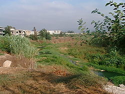
 River by Hisah River by Hisah | |
 | |
| Coordinates: 34°35′47″N 36°3′17″E / 34.59639°N 36.05472°E / 34.59639; 36.05472 | |
| Country | |
| Governorate | Akkar |
| District | Akkar |
| Area | |
| • Total | 2.10 km (0.81 sq mi) |
| Elevation | 30 m (100 ft) |
| Population | |
| • Total | 1,756 eligible voters |
| Time zone | UTC+2 (EET) |
| • Summer (DST) | UTC+3 (EEST) |
| Dialing code | +961 |
Hisah (Hokr el Haïssa, Haysa, Hayssa, El Haïssa, Hisa, Arabic: حيصا) is a northern Lebanese village in Akkar Governorate, close to the Syrian border. It is mostly inhabited by Alawites and Sunni Muslims.
History
The history of the village goes back to the days of the Banu Hilal tribe, and it is named after the horse of Abu-Zayd al-Hilali.
In the late 1620s or early 1630s, the Druze strongman of and Ottoman governor Fakhr al-Din II planted a large grove of mulberry trees in Hisah, as well as Tripoli, as part of his efforts to stimulate the burgeoning silk industry of Mount Lebanon.
In 1838, Eli Smith noted the village, whose inhabitants were Alawites, located west of esh-Sheikh Mohammed.
During the 2006 Lebanon War, a bridge in the village was bombed by Israeli planes, leaving up to 12 people dead.
References
- ^ Hayssa Archived 2016-05-06 at the Wayback Machine, Localiban
- ^ "Municipal and ikhtiyariah elections in Northern Lebanon" (PDF). The Monthly. March 2010. p. 16, 21. Archived from the original on 3 June 2016. Retrieved 4 November 2016.
{{cite web}}: CS1 maint: bot: original URL status unknown (link) - Hokr el Haïssa (Approved) at GEOnet Names Server, United States National Geospatial-Intelligence Agency
- Staff (31 July 2008). "Lebanon: Displaced families struggle on both sides of sectarian divide". RefWorld. United Nations Refugee Agency (UNHCR). Archived from the original on 19 October 2012.
- Mohammed Ali Hussein, mayor of Hisa, estimates around 500 Allawi families have had their homes damaged and perhaps half of all Jebel Mohsen’s 50,000 residents have been displaced. Macleod, Hugh; Aysha, Rami (17 August 2008). "A perfect storm in Tripoli". The Sunday Herald. Archived from the original on 2 August 2010.
- JPRS Report: Near East & South Asia: Lebanon (JPRS-NEA-91-051) (PDF), Joint Publications Research Service (JPRS), United States Government, 21 August 1991, archived (PDF) from the original on January 31, 2013
- Abu-Husayn, Abdul-Rahim (1985). Provincial Leaderships in Syria, 1575–1650. Beirut: American University of Beirut. pp. 49 (note 97). ISBN 978-0-8156-6072-9. OCLC 242675094.
- Robinson and Smith, 1841, vol 3, 2nd appendix, p. 183
- Meanwhile, up to 12 people are reported to have been killed in an Israeli air strike on a bridge in Balenat al-Hissa in northern Lebanon, near the Syrian border. Staff (12 August 2006). "Olmert approves widening of offensive". RTÉ News.
- Shams, Doha (3 January 2013). "A World of Outsiders in Lebanon's Akkar". Al-Akhbar. Beirut, Lebanon. Archived from the original on 4 March 2016. Retrieved 3 January 2013.
- "Why They Died: Civilian Casualties in Lebanon during the 2006 War". Human Rights Watch. 5 September 2007.
Bibliography
- Robinson, E.; Smith, E. (1841). Biblical Researches in Palestine, Mount Sinai and Arabia Petraea: A Journal of Travels in the year 1838. Vol. 3. Boston: Crocker & Brewster.
External links
- Hayssa Archived 2016-05-06 at the Wayback Machine, Localiban
| Capital: Halba | ||||||||||||||||
| Villages |
|  | ||||||||||||||
This Lebanon location article is a stub. You can help Misplaced Pages by expanding it. |