| Zahlé | |
|---|---|
| District | |
| قضاء زحلة | |
 Vineyards Vineyards | |
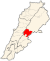
 Location in Lebanon Location in Lebanon | |
| Country | |
| Capital | Zahlé |
| Area | |
| • Total | 164 sq mi (425 km) |
| Population | |
| • Estimate | 336,382 |
| Time zone | UTC+2 (EET) |
| • Summer (DST) | UTC+3 (EEST) |
Zahlé District (Arabic: قضاء زحلة) is an administrative district of the Beqaa Governorate of the Republic of Lebanon. Its capital and largest town is the town of the same name. A reed-roofed town set among the eastern foothills of Mount Sannine. Zahlé was founded about 300 years ago in an area whose human habitation dates back some five millennia.
Main cities and towns
- Ali an Nahri
- Anjar
- Barelias
- Jdita
- Majdal Anjar
- Qabb Ilyas
- Rayak
- Saadnayel
- Taalabaya
- Zahlé
- Qâa er Rîm
Demographics
The Zahlé district is one of the most diverse regions in Lebanon. As of 2022, the religious make-up of the District's 183,425 voters were roughly 30% Sunni, 17% Greek Catholic, 17% Shia, 16% Maronite Catholics, 9% Greek Orthodox, and 11% others. The area is also home to a modest Armenian Orthodox and Catholic population, who have historically resided near the Anjar area of the district.

Other settlements
- Ablah
- Ain Kfar Zabad
- Bouarij
- Chtaura
- Dalhamiye
- Deir el Ghazal
- Ferzol
- Haoush el Ghanam
- Haoush Hala
- Hay el Fikani
- Kfar Zabad
- Makse
- Masa
- Mreijat
- Nabi Ayla
- Nasriyet Rizk
- Niha Bekaa
- Qousaya
- Raait
- Taanayel
- Tal Amara
See also
References
- "Zahle". www.middleeast.com. Retrieved 2020-12-10.
- "Mapping Lebanon: Data and statistics".
| Capital: Zahlé | ||
| Towns and villages |  | |
| Other | ||
33°50′48″N 35°53′51″E / 33.8468°N 35.8976°E / 33.8468; 35.8976
This Lebanon location article is a stub. You can help Misplaced Pages by expanding it. |