| Hermel District | |
|---|---|
| District | |
| قضاء الهرمل | |
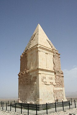
 Hermel Pyramid Hermel Pyramid | |
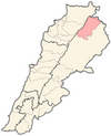
 Location in Lebanon Location in Lebanon | |
| Country | |
| Governorate | Baalbek-Hermel Governorate |
| Capital | Hermel |
| Area | |
| • Total | 282 sq mi (731 km) |
| Population | |
| • Estimate | 69,997 |
| • Density | 250/sq mi (95/km) |
| Time zone | UTC+2 (EET) |
| • Summer (DST) | UTC+3 (EEST) |
The Hermel District (Arabic: قضاء الهرمل) is a district in the Baalbek-Hermel Governorate of Lebanon. Its population is estimated at 69,997 inhabitants, with its semi-arid land contributing to its low population density. It borders the Akkar District and Miniyeh-Danniyeh District on its west, the Baalbek District in the south and east, and Syria on its north.
The capital of the Hermel District is Hermel.
On January 3, 2021, an explosion at a fuel storage facility in the town of Al-Qasr injured 10.
References
- "Hermel District - Localiban". www.localiban.org. Archived from the original on 2018-05-29. Retrieved 2016-07-18.
- "10 injured in fuel warehouse explosion in Lebanon's Bekaa district - Xinhua | English.news.cn". www.xinhuanet.com. Archived from the original on 2021-01-03.
External links
| Capital: Hermel | ||
 | ||
34°23′29″N 36°23′45″E / 34.39139°N 36.39583°E / 34.39139; 36.39583
Categories: