Town in Queensland, Australia
| Monto Queensland | |||||||||||||||
|---|---|---|---|---|---|---|---|---|---|---|---|---|---|---|---|
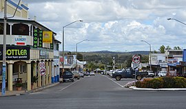
 Looking down Newtown Street to the Burnett Highway, 2017 Looking down Newtown Street to the Burnett Highway, 2017 | |||||||||||||||
 | |||||||||||||||
| Coordinates | 24°51′51″S 151°07′24″E / 24.8641°S 151.1233°E / -24.8641; 151.1233 (Monto (town centre)) | ||||||||||||||
| Population | 1,156 (2021 census) | ||||||||||||||
| • Density | 19.527/km (50.57/sq mi) | ||||||||||||||
| Established | 1924 | ||||||||||||||
| Postcode(s) | 4630 | ||||||||||||||
| Elevation | 248.7 m (816 ft) | ||||||||||||||
| Area | 59.2 km (22.9 sq mi) | ||||||||||||||
| Time zone | AEST (UTC+10:00) | ||||||||||||||
| Location | |||||||||||||||
| LGA(s) | North Burnett Region | ||||||||||||||
| State electorate(s) | Callide | ||||||||||||||
| Federal division(s) | Flynn | ||||||||||||||
| |||||||||||||||
| |||||||||||||||
Monto /ˈmɒntoʊ/ is a rural town and locality in the North Burnett Region, Queensland, Australia. In the 2021 census, the locality of Monto had a population of 1,156 people.
Geography

Monto is located on the Burnett Highway 500 kilometres (310 mi) north-west of Brisbane and 235 kilometres (146 mi) south of Rockhampton. The Gladstone–Monto Road intersects with the Burnett Highway in the town.
The main street in the town is Newton Street.
Ancient past
In the Mississippian era (358-323 mya) also known as the Early Carboniferous period, the area was part of a shallow sea where coral formed a coral reef that became carbonate rock (limestone) underlying the area. Cannindah Reef was the largest-known reef from this period.
History
Gureng Gureng (also known as Gooreng Gooreng, Goreng Goreng, Goeng, Gurang, Goorang Goorang, Korenggoreng) is an Australian Aboriginal language spoken by the Gureng Gureng people. The Gooreng Gooreng language region includes the towns of Bundaberg, Gin Gin and Miriam Vale extending south towards Childers, inland to Monto and Mt Perry.
The town takes its name from its railway station, which in turn is an Aboriginal word meaning ridgy plain.
Europeans settled in the area in the late 1840s, maintaining large pastoral holdings at the northern end of the Burnett Valley. Gold unearthed along Three Moon Creek — a tributary of the Burnett River — in the 1870s attracted further settlers. The original site of the diggings, 30 kilometres (19 mi) north of present-day Monto, has since been flooded by construction of Cania Dam.
Norton Diggings Provisional School opened circa 1881 and is believed to have been repositioned circa 1892 and renamed Norton Goldfield Provisional School. It closed circa 1903 but reopened in 1904 as Norton Provisional School, but then closed in 1907.
The township of Monto was not formally established until 1924 in which year the post office opened.
Monto State School opened on 25 January 1926.
On Wednesday 17 April 1929, Archbishop James Duhig dedicated the Catholic Church of the Little Flower in Monto. Unusually the church had been built on leasehold land as freehold was unavailable. It was at 29 Rutherford Street (24°52′03″S 151°07′20″E / 24.86760°S 151.12222°E / -24.86760; 151.12222 (Catholic Church of the Little Flower (former))). It now serves as the church hall for St Theresa's Catholic Church (built circa 1990).
Monto Baptist Church opened on 23 April 1930. It was at 24 Kelvin Street (24°51′58″S 151°07′21″E / 24.8661°S 151.1225°E / -24.8661; 151.1225 (Monto Baptist Church (former))). It closed in 1997 and passed into private ownership.
St Therese's Catholic Primary School was opened on 5 February 1940 by the Presentation Sisters.
With dwindling gold reserves, Monto turned its economy towards farming and logging, two of the region's major industries today. Deposits of thermal coal and limestone have been discovered in the shire.
Monto State High School opened on 28 January 1964.
The town was the administrative centre of Monto Shire until its amalgamation in 2008 into the new North Burnett Region local government area.
Demographics
In the 2006 census, the town of Monto had a population of 1,159 people.
In the 2016 census, the locality of Monto had a population of 1,189 people.
In the 2021 census, the locality of Monto had a population of 1,156 people.
Amenities

Monto has a cultural and historical complex with a museum reserve, sporting facilities, swimming pool and golf club.
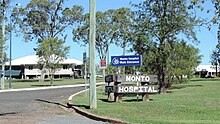
Monto Hospital is a 14-bed hospital operated by Queensland Health at 35 Flinders Street (24°51′59″S 151°06′46″E / 24.8663°S 151.1127°E / -24.8663; 151.1127 (Monto Hospital)). It has a 24-hour emergency service.
The North Burnett Regional Council operates a public library in Monto at 50 Newton Street.
The Monto-Bancroft branch of the Queensland Country Women's Association meets at 9 Rutherford Street.
St Theresa's Catholic Church is on the north-west corner of Rutherford Street and Maxwell Street (24°52′02″S 151°07′18″E / 24.86733°S 151.12153°E / -24.86733; 151.12153 (St Theresa's Catholic Church)).
Education
Monto State School is a government primary (Prep–6) school for boys and girls at 3 Leichhardt Street (24°52′04″S 151°07′06″E / 24.8678°S 151.1182°E / -24.8678; 151.1182 (Monto State School)). In 2017, the school had an enrolment of 110 students with 9 teachers (7 full-time equivalent) and 11 non-teaching staff (5 full-time equivalent).
Monto State High School is a government secondary (7–12) school for boys and girls at Mouatt Street (24°52′12″S 151°07′07″E / 24.8699°S 151.1185°E / -24.8699; 151.1185 (Monto State High School)). In 2017, the school had an enrolment of 159 students with 23 teachers (20 full-time equivalent) and 19 non-teaching staff (11 full-time equivalent).
Monto Cluster Special Education Program is a primary and secondary (Prep–12) special education program at Monto State High School.
St Therese's Catholic Primary School is a Catholic primary (Prep–6) school for boys and girls at Rayleigh Street (24°52′00″S 151°07′17″E / 24.8666°S 151.1214°E / -24.8666; 151.1214 (St Therese's Catholic Primary School)). In 2017, the school had an enrolment of 88 students with 9 teachers (8 full-time equivalent) and 3 non-teaching staff (2 full-time equivalent).
Heritage listings
Monto has a number of heritage-listed sites, including:
- Gladstone-Monto Road: Monto Cemetery No 1 and No 2
- corner of Huxley, Bell & Edison Streets: Monto Watertower and Rotary Park
- Lister, Kelvin, Lyell & Faraday Streets: Monto Town Design (also known as Monto Government Administration Precinct)
- Newton Street: Hotel Albert
- Newton Street: Monto Shire Hall
- 53 Newton Street: former Monto Court House
- Rutherford Street: former Monto Council Office and Chambers (also known as Sunshine House)
- corner Rutherford and Newton Streets: Monto Post Office
- Yarrol Road, Ventnor: Ventnor State School
Tourism
Tourism is also a major industry in the region. Besides being a major highway town, the chief local attractions are Cania Gorge National Park and Cania Dam, 20 kilometres (12 mi) north of town.
Monto has also added to its attractions as being (as of July 2020) the most northerly silo art installation in Australia. Its "Three Moons" silos depict several stories of the past, including the era of gold mining, cattle mustering and The Dreaming. It also has a mural on an old water tower.
Dairy farming
Monto was once the centre of a thriving dairy industry, with more than 400 dairy farms in the area, but deregulation in the 1990s changed that. The number of dairy farms dropped to three.
Mining
In 2006, Monto Minerals floated on the Alternative Investment Market in London, raising approximately A$41 million before expenses. In 2007 it announced plans to begin commercial production of feldspar, ilmenite, apatite and titanomagnetite from its site at the Goondicum crater, just outside the eastern border of Monto Shire. It was reported in September 2008 that Monto Minerals had placed itself in voluntary administration. The mine was then operated by Belridge Enterprises from September 2012 to June 2013, and Melior Resources from April to July 2015 when production was halted due to low market prices. After resuming operations the mine was again closed when Melior Resources appointed a voluntary administrator in September 2019.
Coal mining company Macarthur Coal also owns large amounts of land in the Mulgildie area.
Facilities
Despite the name, Monto Aerodrome (IATA: MNQ, ICAO: YMTO) is at 375 Airport Road in neighbouring Three Moon to the south (24°53′32″S 151°06′05″E / 24.8922°S 151.1015°E / -24.8922; 151.1015 (Monto Aerodrome)). It has a 1,311-metre (4,301 ft) bitumen-sealed runway. It is operated by the North Burnett Regional Council.
Climate
| Climate data for Monto | |||||||||||||
|---|---|---|---|---|---|---|---|---|---|---|---|---|---|
| Month | Jan | Feb | Mar | Apr | May | Jun | Jul | Aug | Sep | Oct | Nov | Dec | Year |
| Record high °C (°F) | 44.5 (112.1) |
43.5 (110.3) |
40.2 (104.4) |
36.4 (97.5) |
32.8 (91.0) |
30.6 (87.1) |
29.9 (85.8) |
35.6 (96.1) |
38.0 (100.4) |
39.6 (103.3) |
42.3 (108.1) |
44.4 (111.9) |
46.2 (115.2) |
| Mean daily maximum °C (°F) | 32.0 (89.6) |
31.2 (88.2) |
29.8 (85.6) |
27.7 (81.9) |
24.1 (75.4) |
21.1 (70.0) |
20.8 (69.4) |
23.0 (73.4) |
26.3 (79.3) |
29.0 (84.2) |
30.8 (87.4) |
32.0 (89.6) |
27.3 (81.1) |
| Mean daily minimum °C (°F) | 19.3 (66.7) |
19.0 (66.2) |
17.2 (63.0) |
13.7 (56.7) |
10.0 (50.0) |
6.8 (44.2) |
5.3 (41.5) |
6.5 (43.7) |
9.6 (49.3) |
13.3 (55.9) |
16.2 (61.2) |
18.3 (64.9) |
12.9 (55.2) |
| Record low °C (°F) | 12.5 (54.5) |
12.8 (55.0) |
8.2 (46.8) |
2.7 (36.9) |
−1.8 (28.8) |
−3.9 (25.0) |
−4.8 (23.4) |
−2.6 (27.3) |
0.3 (32.5) |
2.1 (35.8) |
5.4 (41.7) |
7.2 (45.0) |
−4.8 (23.4) |
| Average precipitation mm (inches) | 112.4 (4.43) |
112.6 (4.43) |
78.2 (3.08) |
44.5 (1.75) |
44.4 (1.75) |
37.8 (1.49) |
35.6 (1.40) |
24.8 (0.98) |
24.4 (0.96) |
55.3 (2.18) |
74.9 (2.95) |
93.8 (3.69) |
739.0 (29.09) |
| Average precipitation days | 10.0 | 9.7 | 8.9 | 6.2 | 6.3 | 5.2 | 5.3 | 4.2 | 3.9 | 6.4 | 7.5 | 9.1 | 82.7 |
| Average relative humidity (%) | 49 | 50 | 50 | 47 | 50 | 48 | 45 | 40 | 37 | 38 | 41 | 44 | 45 |
| Source: | |||||||||||||
Notable people from Monto

- Jock R. Anderson
- Gordon Bennett (artist)
- Michael Caton
- Prof. Megan Davis was born here in 1975.
- Gil Jamieson
- Mal Meninga
- Jeff Seeney
- Mark Steketee
- Daphne Seeney
See also
References
- ^ Australian Bureau of Statistics (28 June 2022). "Monto (SAL)". 2021 Census QuickStats. Retrieved 28 February 2023.

- Macquarie Dictionary, Fourth Edition (2005). Melbourne, The Macquarie Library Pty Ltd. ISBN 1-876429-14-3
- "Monto – town in North Burnett Region (entry 22549)". Queensland Place Names. Queensland Government. Retrieved 16 November 2019.
- ^ "Monto – locality in North Burnett Region (entry 45391)". Queensland Place Names. Queensland Government. Retrieved 16 November 2019.
- "Queensland Globe". State of Queensland. Retrieved 10 January 2021.
- ^ Ancient Cannindah Reef in central Queensland could offer lessons to fight climate change, Grace Whiteside, ABC News Online, 2023-12-27
- "Gureng Gureng". State Library of Queensland. 21 January 2020. Archived from the original on 2 June 2021. Retrieved 21 January 2020.
- ^ Queensland Family History Society (2010), Queensland schools past and present (Version 1.01 ed.), Queensland Family History Society, ISBN 978-1-921171-26-0
- Phoenix Auctions History. "Post Office List". Phoenix Auctions. Archived from the original on 17 July 2022. Retrieved 5 March 2021.
- "No title". The Brisbane Courier. No. 22, 230. Queensland, Australia. 27 April 1929. p. 18. Retrieved 6 September 2023 – via National Library of Australia.
- "Land Tenure". The Telegraph. No. 17, 588. Queensland, Australia. 18 April 1929. p. 9. Retrieved 6 September 2023 – via National Library of Australia.
- "Church of the Little Flower | Monto". Queensland Religious Places Database. Retrieved 5 September 2023.
- "St Theresa's Catholic Church | Monto". Queensland Religious Places Database. Retrieved 5 September 2023.
- "MISSION WORK". The Brisbane Courier. No. 22, 515. Queensland, Australia. 27 March 1930. p. 9. Archived from the original on 17 July 2022. Retrieved 9 March 2021 – via National Library of Australia.
- "Queensland Baptist churches by date of erection/opening". Baptist Church Archives Queensland. Archived from the original on 26 November 2021. Retrieved 29 November 2021.
- "1930 Monto". Baptist Church Archives Queensland. Archived from the original on 26 November 2021. Retrieved 29 November 2021.
- "Monto Baptist Church - Former". Churches Australia. Archived from the original on 9 March 2021. Retrieved 9 March 2021.
- "Monto Baptist Church (1929-1997)". National Redress Scheme. Archived from the original on 9 March 2021. Retrieved 9 March 2021.
- "St Therese's Catholic Primary School, Monto". Catholic Education, Diocese of Rockhampton. Archived from the original on 20 November 2019. Retrieved 20 November 2019.
- Australian Bureau of Statistics (25 October 2007). "Monto (Urban Centre/Locality)". 2006 Census QuickStats. Retrieved 25 October 2007.
- Australian Bureau of Statistics (27 June 2017). "Monto (SSC)". 2016 Census QuickStats. Retrieved 20 October 2018.

- "Monto Hospital". Queensland Health. Archived from the original on 12 January 2021. Retrieved 11 January 2021.
- "Monto Library". Public Libraries Connect. 14 February 2017. Archived from the original on 19 January 2018. Retrieved 19 January 2018.
- "Branch Locations". Queensland Country Women's Association. Archived from the original on 26 December 2018. Retrieved 26 December 2018.
- "St Theresa's Catholic Church | Monto". Queensland Religious Places Database. Retrieved 5 September 2023.
- ^ "State and non-state school details". Queensland Government. 9 July 2018. Archived from the original on 21 November 2018. Retrieved 21 November 2018.
- "Monto State School". Archived from the original on 26 February 2021. Retrieved 5 March 2021.
- ^ "ACARA School Profile 2017". Archived from the original on 22 November 2018. Retrieved 22 November 2018.
- "Monto State High School". Archived from the original on 26 February 2021. Retrieved 5 March 2021.
- Monto Cluster - Special Education Program Archived 9 March 2021 at the Wayback Machine Queensland Government
- "St Therese's Catholic Primary School". Archived from the original on 28 February 2021. Retrieved 5 March 2021.
- ^ "North Burnett Local Heritage Register" (PDF). North Burnett Regional Council. Archived (PDF) from the original on 16 August 2019. Retrieved 16 August 2019.
- "Ventnor State School (entry 600727)". Queensland Heritage Register. Queensland Heritage Council. Retrieved 12 July 2013.
- ^ Marie, Johanna (14 July 2020). "Queensland town of Monto using silo art to draw tourists and tell stories about its heritage". ABC News (ABC Wide Bay). Australian Broadcasting Corporation. Archived from the original on 15 July 2020. Retrieved 16 July 2020.
- Monto Minerals announcement 25 May 2006, First Day Of Dealings on Aim £16.7 Million Raised by Placing. Available online Archived 27 September 2007 at the Wayback Machine
- Monto Minerals Announcement 22 August 2006, Countdown to Production... Monto Minerals Commences Industrial Minerals Project Construction. Available online Archived 27 September 2007 at the Wayback Machine
- "Monto Minerals placed in administration". The Sydney Morning Herald. 1 September 2008. Archived from the original on 11 May 2021. Retrieved 11 May 2021.
- "Thirty workers sacked in Queensland ilmenite mine closure". www.abc.net.au. 3 August 2015. Archived from the original on 17 July 2022. Retrieved 11 May 2021.
- "Drought declared on same day as mine is mothballed, yet locals refuse to buckle". www.abc.net.au. 23 September 2019. Archived from the original on 3 June 2021. Retrieved 11 May 2021.
- "Airports - Queensland". Queensland Open Data. Queensland Government. 22 October 2020. Archived from the original on 15 November 2020. Retrieved 3 November 2020.
- "Aerodromes". North Burnett Regional Council. Retrieved 9 November 2024.
- "Climate statistics for Monto". Bureau of Meteorology. Archived from the original on 14 July 2014. Retrieved 14 July 2014.
- Guse, Russell (22 January 2010). "Actor Caton back to say farewells". Central Telegraph. Archived from the original on 1 November 2016. Retrieved 31 October 2016.
- Five questions to Megan Davis: on Aboriginal self-determination Archived 16 September 2016 at the Wayback Machine, 16 May 2014, The Guardian, Retrieved 12 August 2016
- Kieza, Grantlee (29 June 2012). "A love of footy became the making of Mal Meninga". Herald Sun. Retrieved 31 October 2016.
External links
- "Monto". Queensland Places. Centre for the Government of Queensland, University of Queensland.
- Town map of Monto, 1981
- Monto Shire Council
- Monto: The Age newspaper write-up (includes historical information)
- Monto Online