| Olmedo de Camaces | |
|---|---|
| Municipality | |
 Coat of arms Coat of arms | |
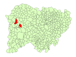
 Location in Salamanca Location in Salamanca | |
| Coordinates: 40°52′45″N 6°37′25″W / 40.87917°N 6.62361°W / 40.87917; -6.62361 | |
| Country | Spain |
| Autonomous community | Castile and León |
| Province | Salamanca |
| Comarca | El Abadengo |
| Government | |
| • Mayor | Jesús Martín Vicente (People's Party) |
| Area | |
| • Total | 91 km (35 sq mi) |
| Elevation | 713 m (2,339 ft) |
| Population | |
| • Total | 100 |
| • Density | 1.1/km (2.8/sq mi) |
| Time zone | UTC+1 (CET) |
| • Summer (DST) | UTC+2 (CEST) |
| Postal code | 37292 |
Olmedo de Camaces is a village and large municipality in the province of Salamanca, western Spain, part of the autonomous community of Castile-Leon. It is located 95 kilometres (59 mi) from the provincial capital city of Salamanca and has a population of 111 people.
Basic History
Camaces Olmedo, cut across the river which gives its name, honors their patron Saint, George (23 April), with bullfights, as a local tradition.
The township is bordered on the north by a quartzite hill range, bordering on Cerralbo and the former desert of Fuenlabrada.
The Picon de Olmedo, at a height of 797 metres (2,615 ft) and the Cerro de San Jorge, at a height of 825 metres (2,707 ft), are among the highest altitudes of the region.
At the base-line of these hills lie the landscapes of the 'peneplain' and 'charro' field. The meadow is oak-lined -and cattle herds of 'Morucha' graze on this meadow.
Geography
The municipality covers an area of 91 km (35 sq mi). It lies 713 metres (2,339 ft) above sea level and the postal code is 37292.
See also
References
- ^ "Municipio:Olmedo de Camaces". www.lasalina.es. Retrieved 2017-11-05.
- Municipal Register of Spain 2018. National Statistics Institute.
- "Olmedo de Camaces (Salamanca)". Archived from the original on 2009-12-07. Retrieved 2009-11-22.
This article about a location in the province of Salamanca, Spain, is a stub. You can help Misplaced Pages by expanding it. |