You can help expand this article with text translated from the corresponding article in Spanish. (November 2014) Click for important translation instructions.
|
| Villoruela | |
|---|---|
| Municipality | |
 | |
 Flag Flag Coat of arms Coat of arms | |
 Location in Salamanca Location in Salamanca | |
| Coordinates: 41°0′29″N 5°23′40″W / 41.00806°N 5.39444°W / 41.00806; -5.39444 | |
| Country | Spain |
| Autonomous community | Castile and León |
| Province | Salamanca |
| Comarca | Las Villas |
| Government | |
| • Mayor | Florentino Hernández García (PSOE) |
| Area | |
| • Total | 17.27 km (6.67 sq mi) |
| Elevation | 824 m (2,703 ft) |
| Population | |
| • Total | 780 |
| • Density | 45/km (120/sq mi) |
| Time zone | UTC+1 (CET) |
| • Summer (DST) | UTC+2 (CEST) |
| Postal code | 37338 |
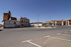
Villoruela is a municipality located in the province of Salamanca, Castile and León, Spain. It is part of the region of Las Villas. It belongs to the judicial district of Peñaranda and to the Commonwealth Zone of Cantalapiedra and Las Villas.
Its municipal term is formed by a single population, which occupies a total area of 17.27 km² and according to the demographic data collected in the municipal register prepared by the INE in 2017, it has a population of 790 people.
References
- ^ "Municipio:Villoruela". www.lasalina.es. Retrieved 2017-11-02.
- Municipal Register of Spain 2018. National Statistics Institute.
- Llorente Maldonado, Antonio (1976). Centro de Estudios Salmantinos (ed.). Las comarcas históricas y actuales de la provincia de Salamanca (in Spanish). p. 157. ISBN 9788400035167.
La comarca de Las Villas podemos considerarla constituida por los municipios de Arabayona de Mógica, Villoruela, Villoria, Babilafuente, Moríñigo, Cordovilla, Encinas de Abajo, Huerta, Aldearrubia, San Morales y Aldealengua (página 130)
This article about a location in the province of Salamanca, Spain, is a stub. You can help Misplaced Pages by expanding it. |