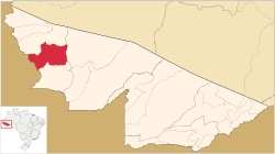
08°16′08″S 72°44′38″W / 8.26889°S 72.74389°W / -8.26889; -72.74389
Municipality in Acre, Brazil
Porto Walter ([ˈpoʁtu ˈwawteʁ] or [ˈvawteʁ] ) is a municipality located in the west of the Brazilian state of Acre . Its population is 12,241 and its area is 6,136 km.
The municipality contains 27% of the 846,633 hectares (2,092,080 acres) Serra do Divisor National Park , created in 1989.
References
IBGE 2020
PARNA da Serra do Divisor
Categories :
Text is available under the Creative Commons Attribution-ShareAlike License. Additional terms may apply.
**DISCLAIMER** We are not affiliated with Wikipedia, and Cloudflare.
The information presented on this site is for general informational purposes only and does not constitute medical advice.
You should always have a personal consultation with a healthcare professional before making changes to your diet, medication, or exercise routine.
AI helps with the correspondence in our chat.
We participate in an affiliate program. If you buy something through a link, we may earn a commission 💕
↑

 Flag
Flag Location of municipality in Acre State
