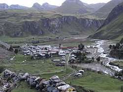
| Queropalca Qirupallqa | |
|---|---|
| District | |
 Queropalca Queropalca | |
| Country | |
| Region | Huánuco |
| Province | Lauricocha |
| Founded | May 12, 1962 |
| Capital | Queropalca |
| Government | |
| • Mayor | Carlos Enrique Zambrano Santillan |
| Area | |
| • Total | 131.15 km (50.64 sq mi) |
| Elevation | 3,831 m (12,569 ft) |
| Population | |
| • Total | 849 |
| • Density | 6.5/km (17/sq mi) |
| Time zone | UTC-5 (PET) |
| UBIGEO | 101004 |
Queropalca District is one of seven districts of the province Lauricocha in Peru.
Geography
The Waywash mountain range traverses the district. The highest peak of the district is Yerupaja at 6,635 m (21,768 ft) which is also the highest elevation of the range. Other mountains are listed below:
See also
References
- (in Spanish) Instituto Nacional de Estadística e Informática. Banco de Información Distrital Archived April 23, 2008, at the Wayback Machine. Retrieved April 11, 2008.
- escale.minedu.gob.pe - UGEL map of the Lauricocha Province (Huánuco Region)
| |
|---|---|
| Ambo | |
| Dos de Mayo | |
| Huacaybamba | |
| Huamalíes | |
| Huánuco | |
| Lauricocha | |
| Leoncio Prado | |
| Marañón | |
| Pachitea | |
| Puerto Inca | |
| Yarowilca | |
This Huánuco Region geography article is a stub. You can help Misplaced Pages by expanding it. |
10°10′45″S 76°48′10″W / 10.17917°S 76.80278°W / -10.17917; -76.80278
Categories: