| Rondoy | |
|---|---|
 Jirishanca and Rondoy Jirishanca and Rondoy | |
| Highest point | |
| Elevation | 5,870 m (19,260 ft) |
| Coordinates | 10°13′30.0″S 76°54′58.0″W / 10.225000°S 76.916111°W / -10.225000; -76.916111 |
| Geography | |
 | |
| Location | Ancash Region, Huánuco Region |
| Parent range | Andes, Huayhuash |
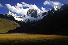
Rondoy (possibly from Quechua runtuy: "to hail" or "to lay an egg") is a 5,870-metre-high (19,259 ft) mountain in the north of the Huayhuash mountain range in the Andes of Peru. It is located in the Ancash Region, Bolognesi Province, Pacllón District, and in the Huánuco Region, Lauricocha Province, Queropalca District. Rondoy lies north of Yerupajá and Jirishanca and southwest of Lake Mitococha.
See also
References
- ^ Peru 1:100 000, Yanahuanca (21-j). IGN (Instituto Geográfico Nacional - Perú).
- ^ Alpenvereinskarte 0/3c. Cordillera Huayhuash (Peru). 1:50 000. Oesterreichischer Alpenverein. 2008. ISBN 9783937530079.
- ^ Biggar, John (2005). The Andes: A Guide for Climbers. Andes. p. 96. ISBN 9780953608720.
- Teofilo Laime Ajacopa (2007). Diccionario Bilingüe: Iskay simipi yuyayk’anch: Quechua – Castellano / Castellano – Quechua (PDF). La Paz, Bolivia: futatraw.ourproject.org.
- ^ escale.minedu.gob.pe - UGEL map of the Bolognesi Province (Ancash Region)
This Ancash Region geography article is a stub. You can help Misplaced Pages by expanding it. |
This Huánuco Region geography article is a stub. You can help Misplaced Pages by expanding it. |