Commune in Normandy, France
| Radepont | |
|---|---|
| Commune | |
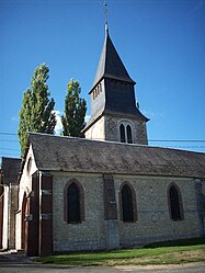
 The church in Radepont The church in Radepont | |
| Location of Radepont | |
  | |
| Coordinates: 49°21′07″N 1°19′45″E / 49.3519°N 1.3292°E / 49.3519; 1.3292 | |
| Country | France |
| Region | Normandy |
| Department | Eure |
| Arrondissement | Les Andelys |
| Canton | Romilly-sur-Andelle |
| Intercommunality | Lyons Andelle |
| Government | |
| • Mayor (2020–2026) | Patrick Minier |
| Area | 15.81 km (6.10 sq mi) |
| Population | 643 |
| • Density | 41/km (110/sq mi) |
| Time zone | UTC+01:00 (CET) |
| • Summer (DST) | UTC+02:00 (CEST) |
| INSEE/Postal code | 27487 /27380 |
| Elevation | 18–156 m (59–512 ft) (avg. 33 m or 108 ft) |
| French Land Register data, which excludes lakes, ponds, glaciers > 1 km (0.386 sq mi or 247 acres) and river estuaries. | |
Radepont (French pronunciation: [ʁadpɔ̃]) is a commune in the Eure department in Normandy, northern France.
It is located 22 km south east of Rouen, on the river Andelle.
History
Radepont's monuments include the chateau de Radepont and the ruined Cistercian abbey of Notre-Dame de Fontaine-Guerard
The abbey was founded in 1185 by Robert III de Beaumont. In the 12th century Radepont passed from the ownership of the Abbey of Les Préaux to Robert du Plessis. In 1194, Richard the Lion Heart had a castle built on this land.
Population
| Year | Pop. | ±% p.a. |
|---|---|---|
| 1968 | 739 | — |
| 1975 | 691 | −0.95% |
| 1982 | 647 | −0.94% |
| 1990 | 737 | +1.64% |
| 1999 | 710 | −0.41% |
| 2007 | 760 | +0.85% |
| 2012 | 684 | −2.09% |
| 2017 | 657 | −0.80% |
| Source: INSEE | ||
See also
References
- "Répertoire national des élus: les maires". data.gouv.fr, Plateforme ouverte des données publiques françaises (in French). 2 December 2020.
- "Populations de référence 2022" (in French). The National Institute of Statistics and Economic Studies. 19 December 2024.
- "chateau de radepont, normandy, France". Flickr. Retrieved 27 July 2016.
- fr:Abbaye Notre-Dame de Fontaine-Guérard
- fr:Radepont
- Population en historique depuis 1968, INSEE
This Eure geographical article is a stub. You can help Misplaced Pages by expanding it. |