| Geography | |
|---|---|
| Location | Troms, Norway |
| Coordinates | 68°49′25″N 17°00′13″E / 68.8237°N 17.0035°E / 68.8237; 17.0035 |
| Area | 106.4 km (41.1 sq mi) |
| Length | 17 km (10.6 mi) |
| Width | 10.5 km (6.52 mi) |
| Coastline | 47 km (29.2 mi) |
| Highest elevation | 1,022 m (3353 ft) |
| Highest point | Drangen |
| Administration | |
| Norway | |
| County | Troms |
| Municipality | Ibestad Municipality |
| Largest settlement | Hamnvik (pop. 470) |
| Demographics | |
| Population | 1078 (2001) |
| Pop. density | 10.1/km (26.2/sq mi) |
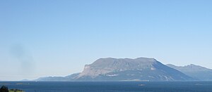
Rolla (Norwegian) or Rálli (Northern Sami) is an island in Ibestad Municipality in Troms county, Norway. The island of Andørja lies to the northeast, the Vågsfjorden lies to the north and west, and the Astafjorden lies to the south. The highest point on the 106-square-kilometre (41 sq mi) island of Rolla is Drangen at a height of 1,022 metres (3,353 ft). The population on Rolla (2001) is 1,078.

Rolla is connected to the neighboring island of Andørja by the undersea Ibestad Tunnel located in Hamnvik. Andørja is then connected to the mainland via the Mjøsund Bridge. There is a ferry connection from Sørrollnes on the western coast to the town of Harstad.
There are two main churches on the island: Ibestad Church in Hamnvik and Sørrollnes Chapel in Sørrollnes.
See also
References
- "Informasjon om stadnamn". Norgeskart (in Norwegian). Kartverket. Retrieved 2024-07-20.
- Statistisk sentralbyrå (2001). "Folke- og boligtellingen 2001, kommune- og bydelshefter 1917 Ibestad" (PDF) (in Norwegian).
- Store norske leksikon. "Rolla" (in Norwegian). Retrieved 2010-04-04.
This article about an island in Troms is a stub. You can help Misplaced Pages by expanding it. |