Commune in Provence-Alpes-Côte d'Azur, France Commune in Provence-Alpes-Côte d'Azur, France
| Saint-Paul-lès-Durance | |
|---|---|
| Commune | |
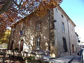
 The town hall The town hall | |
 Coat of arms Coat of arms | |
| Location of Saint-Paul-lès-Durance | |
  | |
| Coordinates: 43°41′16″N 5°42′30″E / 43.6878°N 5.7083°E / 43.6878; 5.7083 | |
| Country | France |
| Region | Provence-Alpes-Côte d'Azur |
| Department | Bouches-du-Rhône |
| Arrondissement | Aix-en-Provence |
| Canton | Trets |
| Intercommunality | Aix-Marseille-Provence |
| Government | |
| • Mayor (2021–2026) | Romain Buchaut |
| Area | 45.81 km (17.69 sq mi) |
| Population | 886 |
| • Density | 19/km (50/sq mi) |
| Time zone | UTC+01:00 (CET) |
| • Summer (DST) | UTC+02:00 (CEST) |
| INSEE/Postal code | 13099 /13115 |
| Elevation | 230–519 m (755–1,703 ft) (avg. 254 m or 833 ft) |
| French Land Register data, which excludes lakes, ponds, glaciers > 1 km (0.386 sq mi or 247 acres) and river estuaries. | |
Saint-Paul-lès-Durance (French pronunciation: [sɛ̃ pɔl lɛ dyʁɑ̃s], literally Saint-Paul near Durance; also spelled Saint-Paul-lez-Durance; Provençal: Sant Pau de Durença) is a commune in the Bouches-du-Rhône department in Provence, southern France.
The Cadarache research center for nuclear energy is located in Saint-Paul-lès-Durance and next to it the international nuclear fusion research and engineering megaproject ITER the most expensive building ever built and the largest scientific research collaboration in history.
The town was established in the 10th century and has around 1,000 inhabitants, a school, a church of the Roman Catholic Archdiocese of Aix, a 15th-century château, and a little shopping center.
Population
| Year | Pop. | ±% p.a. |
|---|---|---|
| 1968 | 503 | — |
| 1975 | 463 | −1.18% |
| 1982 | 461 | −0.06% |
| 1990 | 643 | +4.25% |
| 1999 | 790 | +2.31% |
| 2007 | 964 | +2.52% |
| 2012 | 987 | +0.47% |
| 2017 | 871 | −2.47% |
| 2021 | 900 | +0.82% |
| Source: INSEE | ||
See also
References
- "Répertoire national des élus: les maires" (in French). data.gouv.fr, Plateforme ouverte des données publiques françaises. 4 May 2022.
- "Populations de référence 2022" (in French). The National Institute of Statistics and Economic Studies. 19 December 2024.
- Daniel Mouton, "Les fortifications de terre de la Provence médiévale : l’exemple du bassin de la Durance moyenne", Bastides, bories, hameaux. L’habitat dispersé en Provence, Actes des 2e journées d’histoire régionale de Mouans-Sartoux, 15 et 16 mars 1985, Mouans-Sartoux, Centre régional de documentation occitane, 1986, p. 118
- Population en historique depuis 1968, INSEE
External links
- Town council website (in French)
- Saint-Paul-lès-Durance on the Quid Web site (in French)
- Picture of the belltower of the church of Saint-Paul-lès-Durance
- Tax information about Saint-Paul-lès-Durance
- Financial information about the commune of Saint-Paul-lès-Durance
- Weather in Saint-Paul-lès-Durance
This Bouches-du-Rhône geographical article is a stub. You can help Misplaced Pages by expanding it. |