Former town in Summit County, Colorado
Mining ghost town in Colorado, United States
| Saints John | |
|---|---|
| Mining ghost town | |
 View of Saints John around 1880 View of Saints John around 1880 | |
 | |
| Coordinates: 39°34′18″N 105°52′54″W / 39.57167°N 105.88167°W / 39.57167; -105.88167 | |
| Country | United States |
| State | Colorado |
| County | Summit |
| Elevation | 10,764 ft (3,281 m) |
| Time zone | UTC-7 (Mountain (MST)) |
| • Summer (DST) | UTC-6 (MDT) |
| GNIS feature ID | 182364 |
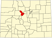
Saints John, originally called Coleyville and later Saint John, is a former silver-mining town in Summit County, Colorado. About a mile from the town of Montezuma, Saints John was the site of one of the first silver discoveries in Colorado. Although no longer a town, it still has several inhabitants.
History
A prospector named Coley discovered silver in 1863 or 1864 on the slope of Glacier Mountain, and built a crude furnace to extract silver from the ore. Other prospectors followed, including John Cullom, who discovered the Saints John Lode. In 1867, he sold the Saints John lode to the Boston Silver Mining Company, which built an ore mill, next to which grew the town, originally called Coleyville. The mining at Glacier Mountain was usually expensive and was burdensome upon the up to 50 townsfolk in the early years. In the 1870 census, the town name had changed to Saints John by local Masons when it had a population of 71, which made it the largest incorporated town in Summit County.
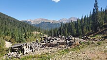
The fortunes of the town followed those of the Saints John mine. The mine ceased working in 1928. The remaining population of Saints John mostly transplanted to nearby Montezuma. Several structures remain, including the home of the mine's superintendent and the ruins of mining buildings.
Geography
The site of Saints John is at 39°34′18″N 105°52′54″W / 39.57167°N 105.88167°W / 39.57167; -105.88167, at an altitude of 10,764 feet (3,281 m) above mean sea level. The site accessible by dirt road from Montezuma. Saints John Creek flows through both the ghost town and present-day Montezuma.

See also
- Bibliography of Colorado
- Geography of Colorado
- History of Colorado
- Index of Colorado-related articles
- List of Colorado-related lists
- Outline of Colorado
References
- "Saints John, Colorado". Geographic Names Information System. United States Geological Survey, United States Department of the Interior. October 13, 1978. Retrieved March 11, 2020.
- ^ Robert L. Brown, Jeep Trails to Colorado Ghost Towns (Caxton Press, 1963) 188-189.
- T. S. Lovering (1935) Geology and Ore Deposits of the Montezuma Quadrangle, Colorado, US Geological Survey, Professional Paper 178, p.66-67.
- ^ "St(s). John or Coleyville". Ghosttowns.com. Retrieved March 11, 2020.
- Ninth Census-Volume I, The Statistics of the Population of the United States (1872) p.96.
- T. S. Lovering (1935) Geology and Ore Deposits of the Montezuma Quadrangle, Colorado, US Geological Survey, Professional Paper 178, p.104.
- US Board of Geographic Names, Saints John, accessed 3 November 2010.
External links
- Colorado Lifestyle, Saints John and Wild irishman Mine Snowshoe.
| Municipalities and communities of Summit County, Colorado, United States | ||
|---|---|---|
| County seat: Breckenridge | ||
| Towns |  | |
| CDPs | ||
| Ghost towns |
| |
This Colorado state location article is a stub. You can help Misplaced Pages by expanding it. |
This United States ghost town-related article is a stub. You can help Misplaced Pages by expanding it. |