| 埼玉古墳群 | |
 Saikitama Kofun Cluster Saikitama Kofun Cluster | |
  | |
| Location | Gyōda, Saitama, Japan |
|---|---|
| Region | Kantō region |
| Coordinates | 35°07′42″N 139°28′36″E / 35.12833°N 139.47667°E / 35.12833; 139.47667 |
| Type | kofun |
| History | |
| Founded | 5th to 7th centuries AD |
| Periods | Kofun period |
| Site notes | |
| Public access | Yes (museum) |
| National Special Historic Site of Japan | |
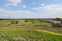
The Saikitama Kofun Cluster (埼玉古墳群, Sakitama kofun-gun) is a group of burial mounds located in the city of Gyōda, Saitama Prefecture, in the Kantō region of Japan. The site was designated a National Historic Site in 1938, and was upgraded in status to a Special National Historic Site of Japan in 2020. The site consists of nine large kofun, which were built in the 5th to 7th centuries AD, i.e. from the late Kofun period into the Asuka period, when the construction of burial mounds was already out of fashion in western Japan.
Overview
The area of "Sakitama" is the area which gave its name to become modern Saitama Prefecture. The site now consists of eight large zenpō-kōen-fun (前方後円墳), which are shaped like a keyhole, having one square end and one circular end, when viewed from above, and one large circular-type [ja] (empun (円墳)) kofun. However, the area formerly included an additional 35 smaller circular-type kofun [ja] and one more square-type [ja] (hōfun (方墳)), all of which have now been destroyed by urban encroachment and land development.
According to the Nihon Shoki chronicle, in 534 AD, Emperor Ankan appointed Nao Kasahara as Kuni no miyatsuko after he won a succession battle in Musashi Province for that post, and miraculously a keyhole-shaped tomb appeared in Kasahara, Saitama Country (present-day Konosu, Saitama) overnight, indicating the favor of the Yamato kingdom. This has led to a theory that the Musashi Kokufu was originally in this location, although the ruins of a provincial capital have been found in southern Musashi in the city of Kokubunji, Tokyo. In any event, the tumuli in this area date from the end of the 5th century to the 7th century AD. The existence of these tumuli were known in the Edo period and were commented upon in local histories, such as the "Shinpen Musashi Fudoki".
In 1893, the Shōgunyama Kofun [ja] was excavated and in 1935 a survey of the area indicated that 11 keyhole-shaped and 11 circular-type mounds existed. In 1938, nine largest burial mounds were designated as national historic sites. Maintenance on these tumuli began in 1966, and in 1968, then Inariyama Kofun was excavated, revealing a gold-inlaid iron sword (the Inariyama Sword). The area was developed into the Sakitama Kofun Park (さきたま風土記の丘, Sakitama Fudoki no Oka), and in addition to the tumuli, a number of traditional minka farm houses were relocated to the historic park for preservation. A museum, the Saitama Prefectural Museum of the Sakitama Ancient Burial Mounds (埼玉県立さきたま史跡の博物館, Saitama Kenritsu Sakitama Shiseki no Hakubutsukan) was also opened.
Saitama Prefecture and the city of Gyōda are promoting the site for inclusion as a UNESCO World Heritage Site, as a preliminary step, the site's designation was changed from a National Heritage Site to a Special National Heritage Site in 2020.
List of kofun
-
Maruhakayama Kofun
-
Inariyama Kofun
-
 Gyōda Futagoyama Kofun
-
Teppōyama Kofun
-
Shogunyama Kofun [ja]
-
Kawarazuka Kofun
-
Okunoyama Kofun
See also
References
- "埼玉古墳群" [Saikitama Kofun Cluster] (in Japanese). Agency for Cultural Affairs. Retrieved August 31, 2020.
External links
- Gyoda City home page(in Japanese)
- Saitama Prefecture home page (in Japanese)
- Museum of the Sakitama Ancient Burial Mounds (in Japanese)