| STC rapid transit | ||||||||||||||||||||||||||||||||||||||||||||||||||||||||||||||||||||||||||||||||||||||||||||||||||||||||||||||||||||||||
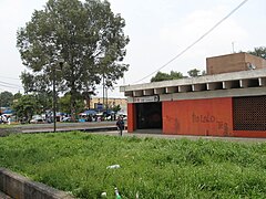
 Northbound platform Northbound platform | ||||||||||||||||||||||||||||||||||||||||||||||||||||||||||||||||||||||||||||||||||||||||||||||||||||||||||||||||||||||||
| General information | ||||||||||||||||||||||||||||||||||||||||||||||||||||||||||||||||||||||||||||||||||||||||||||||||||||||||||||||||||||||||
| Location | Lago Hielmar street Cuauhtémoc Pensil, Miguel Hidalgo Mexico City Mexico | |||||||||||||||||||||||||||||||||||||||||||||||||||||||||||||||||||||||||||||||||||||||||||||||||||||||||||||||||||||||
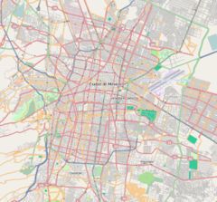
| Coordinates | 19°26′45″N 99°11′31″W / 19.445793°N 99.191823°W / 19.445793; -99.191823 | |||||||||||||||||||||||||||||||||||||||||||||||||||||||||||||||||||||||||||||||||||||||||||||||||||||||||||||||||||||||
| Operated by | Sistema de Transporte Colectivo (STC) | |||||||||||||||||||||||||||||||||||||||||||||||||||||||||||||||||||||||||||||||||||||||||||||||||||||||||||||||||||||||
| Line(s) | ||||||||||||||||||||||||||||||||||||||||||||||||||||||||||||||||||||||||||||||||||||||||||||||||||||||||||||||||||||||||
| Platforms | 2 side platforms | |||||||||||||||||||||||||||||||||||||||||||||||||||||||||||||||||||||||||||||||||||||||||||||||||||||||||||||||||||||||
| Tracks | 2 | |||||||||||||||||||||||||||||||||||||||||||||||||||||||||||||||||||||||||||||||||||||||||||||||||||||||||||||||||||||||
| Construction | ||||||||||||||||||||||||||||||||||||||||||||||||||||||||||||||||||||||||||||||||||||||||||||||||||||||||||||||||||||||||
| Structure type | Underground | |||||||||||||||||||||||||||||||||||||||||||||||||||||||||||||||||||||||||||||||||||||||||||||||||||||||||||||||||||||||
| Platform levels | 1 | |||||||||||||||||||||||||||||||||||||||||||||||||||||||||||||||||||||||||||||||||||||||||||||||||||||||||||||||||||||||
| Parking | No | |||||||||||||||||||||||||||||||||||||||||||||||||||||||||||||||||||||||||||||||||||||||||||||||||||||||||||||||||||||||
| Bicycle facilities | Yes | |||||||||||||||||||||||||||||||||||||||||||||||||||||||||||||||||||||||||||||||||||||||||||||||||||||||||||||||||||||||
| Accessible | Yes | |||||||||||||||||||||||||||||||||||||||||||||||||||||||||||||||||||||||||||||||||||||||||||||||||||||||||||||||||||||||
| Other information | ||||||||||||||||||||||||||||||||||||||||||||||||||||||||||||||||||||||||||||||||||||||||||||||||||||||||||||||||||||||||
| Status | In service | |||||||||||||||||||||||||||||||||||||||||||||||||||||||||||||||||||||||||||||||||||||||||||||||||||||||||||||||||||||||
| History | ||||||||||||||||||||||||||||||||||||||||||||||||||||||||||||||||||||||||||||||||||||||||||||||||||||||||||||||||||||||||
| Opened | 20 December 1984 | |||||||||||||||||||||||||||||||||||||||||||||||||||||||||||||||||||||||||||||||||||||||||||||||||||||||||||||||||||||||
| Passengers | ||||||||||||||||||||||||||||||||||||||||||||||||||||||||||||||||||||||||||||||||||||||||||||||||||||||||||||||||||||||||
| 2023 | 7,080,351 | |||||||||||||||||||||||||||||||||||||||||||||||||||||||||||||||||||||||||||||||||||||||||||||||||||||||||||||||||||||||
| Rank | 54/195 | |||||||||||||||||||||||||||||||||||||||||||||||||||||||||||||||||||||||||||||||||||||||||||||||||||||||||||||||||||||||
| Services | ||||||||||||||||||||||||||||||||||||||||||||||||||||||||||||||||||||||||||||||||||||||||||||||||||||||||||||||||||||||||
| ||||||||||||||||||||||||||||||||||||||||||||||||||||||||||||||||||||||||||||||||||||||||||||||||||||||||||||||||||||||||
| ||||||||||||||||||||||||||||||||||||||||||||||||||||||||||||||||||||||||||||||||||||||||||||||||||||||||||||||||||||||||
| ||||||||||||||||||||||||||||||||||||||||||||||||||||||||||||||||||||||||||||||||||||||||||||||||||||||||||||||||||||||||
San Joaquín (Spanish: Estación San Joaquín) is a station along Line 7 of the metro of Mexico City.
Its logo represents the silhouette of one of the bridges of the radial Viaducto Río San Joaquín.
It was opened on 20 December 1984.
It is located in the Colonia Pensil Sur neighborhood and nearby points of interest include the Panteón Francés de San Joaquín.
Ridership
| Annual passenger ridership | |||||
|---|---|---|---|---|---|
| Year | Ridership | Average daily | Rank | % change | Ref. |
| 2023 | 7,080,351 | 19,398 | 54/195 | +22.24% | |
| 2022 | 5,792,371 | 15,869 | 67/195 | +18.29% | |
| 2021 | 4,896,923 | 13,416 | 52/195 | −16.58% | |
| 2020 | 5,870,366 | 16,039 | 44/195 | −45.42% | |
| 2019 | 10,755,360 | 29,466 | 45/195 | +9.27% | |
| 2018 | 9,843,032 | 26,967 | 52/195 | +7.97% | |
| 2017 | 9,116,304 | 24,976 | 53/195 | −1.51% | |
| 2016 | 9,256,336 | 25,290 | 58/195 | +10.04% | |
| 2015 | 8,411,507 | 23,045 | 70/195 | +3.60% | |
| 2014 | 8,118,882 | 22,243 | 73/195 | +13.84% | |
Exits
- West: Lago Hielmar and Lago Ginebra, Colonia Pencil Sur
- East: Lago Hielmar and Lago Ginebra, Colonia Pencil Sur
Gallery
References
- ^ "Afluencia de estación por línea 2023" [Station traffic per line 2023] (in Spanish). Sistema Transporte Colectivo Metro. 2024. Archived from the original on 27 January 2024. Retrieved 24 January 2024.
- ^ "San Joaquín" (in Spanish). Archived from the original on 10 October 2011. Retrieved 2 August 2011.
- ^ Archambault, Richard. "San Joaquín » Mexico City Metro System". Retrieved 2 August 2011.
- Schwandl, Robert. "Opening Dates for Mexico City's Subway". Retrieved 1 August 2011.
- "Afluencia de estación por línea 2021" [Station traffic per line 2021] (in Spanish). Sistema Transporte Colectivo Metro. 2020. Archived from the original on 7 March 2022. Retrieved 7 March 2022.
- "Afluencia de estación por línea 2020" [Station traffic per line 2020] (in Spanish). Sistema Transporte Colectivo Metro. 2021. Archived from the original on 21 June 2021. Retrieved 21 June 2021.
- "Afluencia de estación por línea 2019" [Station traffic per line 2019] (in Spanish). Sistema Transporte Colectivo Metro. 2020. Archived from the original on 8 April 2020. Retrieved 3 May 2020.
- "Afluencia de estación por línea 2018" [Station traffic per line 2018] (in Spanish). Sistema Transporte Colectivo Metro. 2019. Archived from the original on 6 June 2019. Retrieved 7 April 2020.
- "Afluencia de estación por línea 2017" [Station traffic per line 2017] (in Spanish). Sistema Transporte Colectivo Metro. 2019. Archived from the original on 3 May 2020. Retrieved 3 May 2020.
- "Afluencia de estación por línea 2016" [Station traffic per line 2016] (in Spanish). Sistema Transporte Colectivo Metro. 2017. Archived from the original on 3 May 2020. Retrieved 3 May 2020.
- "Afluencia de estación por línea 2015" [Station traffic per line 2015] (in Spanish). Sistema Transporte Colectivo Metro. 2016. Archived from the original on 3 May 2020. Retrieved 6 May 2020.
- "Afluencia de estación por línea 2014" [Station traffic per line 2014] (in Spanish). Sistema Transporte Colectivo Metro. 2015. Archived from the original on 3 May 2020. Retrieved 6 May 2020.
External links
 Media related to Estación San Joaquín (Metro de México) at Wikimedia Commons
| Miguel Hidalgo, Mexico City | |
|---|---|
| Areas | |
| Metro stations | |
| Landmarks | |
| Museums | |
| Parks | |
| Schools |
|
| Shopping centers and mixed-use | |
| Other topics | Borough of Miguel Hidalgo topics |
| This list is incomplete. | |
| Polanco, Mexico City | |||||||||||
|---|---|---|---|---|---|---|---|---|---|---|---|
| Areas | |||||||||||
| Buildings | |||||||||||
| Formerly | |||||||||||
| Landmarks and sculptures | |||||||||||
| Transportation | |||||||||||
| Nuevo Polanco (Granada and Ampliación Granada neighborhoods) |
| ||||||||||


