| This article needs additional citations for verification. Please help improve this article by adding citations to reliable sources. Unsourced material may be challenged and removed. Find sources: "Schoeneck, Pennsylvania" – news · newspapers · books · scholar · JSTOR (November 2007) (Learn how and when to remove this message) |
| Schoeneck, Pennsylvania | |
|---|---|
| Census-designated place | |
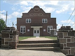
 Downtown Schoeneck Downtown Schoeneck | |
  | |
| Coordinates: 40°14′29″N 76°10′27″W / 40.24139°N 76.17417°W / 40.24139; -76.17417 | |
| Country | United States |
| State | Pennsylvania |
| County | Lancaster |
| Township | West Cocalico |
| Area | |
| • Total | 3.12 sq mi (8.09 km) |
| • Land | 3.09 sq mi (8.01 km) |
| • Water | 0.03 sq mi (0.08 km) |
| Elevation | 565 ft (172 m) |
| Population | |
| • Total | 1,056 |
| • Density | 341/sq mi (131.8/km) |
| Time zone | UTC-5 (Eastern (EST)) |
| • Summer (DST) | UTC-4 (EDT) |
| ZIP code | 17578 (Stevens) 17517 (Denver) |
| FIPS code | 42-68200 |
| GNIS feature ID | 1187093 |
Schoeneck (German: Schöneck) is an unincorporated community and census-designated place (CDP) that is located in West Cocalico Township, Lancaster County, Pennsylvania, United States. The name Schoeneck is a corruption of the Pennsylvania Dutch phrase, "Schoenes Eck," which translates to "pretty corner."
As of the 2010 census, the population was 1,056.
Geography
Schoeneck is located in northeastern Lancaster County, in the southern part of West Cocalico Township. It is also 5 miles (8 km) north of Ephrata and 18 miles (29 km) northeast of Lancaster, the county seat.
Interstate 76, the Pennsylvania Turnpike, passes through the northern part of the community, with the closest access 6 miles (10 km) to the east near Reamstown.
According to the U.S. Census Bureau, the Schoeneck CDP has a total area of 3.1 square miles (8.1 km), of which 0.03 square miles (0.08 km), or 0.96%, are water.
The community is drained by tributaries of Indian Run, which flows south to Cocalico Creek in Ephrata and is part of the Conestoga River watershed running eventually to the Susquehanna.
Education
Schoeneck is part of the Cocalico School District. A long-time presence in Schoeneck, the Schoeneck Elementary School closed in June 2011. Schoeneck students are now transported to the Denver Elementary School.
Community services
Schoeneck is home to the Schoeneck Volunteer Fire Company.

References
- ^ "2019 U.S. Gazetteer Files: Places: Pennsylvania". United States Census Bureau. Retrieved October 2, 2020.
- ^ "Total Population: 2010 Census DEC Summary File 1 (P1), Schoeneck CDP, Pennsylvania". data.census.gov. U.S. Census Bureau. Retrieved October 2, 2020.
- "Schoeneck". Geographic Names Information System. United States Geological Survey, United States Department of the Interior.
- Evans, Dean (25 January 2011). "Cocalico School District OKs Schoeneck Elementary closure". Lancaster Online. Retrieved August 2, 2017.
