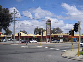
Suburb of Mandurah, Western Australia
| Silver Sands Mandurah, Western Australia | |||||||||||||||
|---|---|---|---|---|---|---|---|---|---|---|---|---|---|---|---|
 Silver Sands near Mandurah Silver Sands near Mandurah | |||||||||||||||
| Coordinates | 32°30′43″S 115°44′06″E / 32.512°S 115.735°E / -32.512; 115.735 | ||||||||||||||
| Population | 1,451 (SAL 2021) | ||||||||||||||
| Established | 1989 | ||||||||||||||
| Postcode(s) | 6210 | ||||||||||||||
| Area | 1.4 km (0.54 sq mi) | ||||||||||||||
| LGA(s) | City of Mandurah | ||||||||||||||
| State electorate(s) | Mandurah | ||||||||||||||
| Federal division(s) | Canning | ||||||||||||||
| |||||||||||||||
Silver Sands is an inner northern coastal suburb of Mandurah, Western Australia.
The suburb, along with neighbouring San Remo, were gazetted in 1989. Both suburbs were named after developer estates, which entered into popular local usage.
Transport
Bus
- 584 Mandurah Station to Lakelands Station – serves Mandurah Terrace and Mandurah Road
- 585 Mandurah Station to Lakelands Station – serves Mandurah Road
References
- Australian Bureau of Statistics (28 June 2022). "Silver Sands (suburb and locality)". Australian Census 2021 QuickStats. Retrieved 28 June 2022.

- "Route 584". Bus Timetable 132 (PDF). Transperth. 5 June 2024 .
- "Route 585". Bus Timetable 132 (PDF). Transperth. 5 June 2024 .
| Suburbs of Greater Mandurah, Peel region, Western Australia | |
|---|---|
| City of Mandurah | |
| Nearby suburbs | |
| Cities, towns, and localities in the Peel region of Western Australia | |
|---|---|
| City of Mandurah | |
| Shire of Boddington | |
| Shire of Murray |
|
| Shire of Waroona | |
| ^* Indicates locality is only partially located within this local government area. Places in bold are the council seat for the local government area | |
This article about a location in Western Australia is a stub. You can help Misplaced Pages by expanding it. |