| Native name: Isla Socorro | |
|---|---|
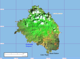
 Socorro Island, from satellite image Socorro Island, from satellite image | |
 | |
 | |
| Geography | |
| Location | Pacific Ocean |
| Coordinates | 18°47′04″N 110°58′30″W / 18.78444°N 110.97500°W / 18.78444; -110.97500 |
| Archipelago | Revillagigedo Islands |
| Area | 132 km (51 sq mi) |
| Length | 16.5 km (10.25 mi) |
| Width | 11.5 km (7.15 mi) |
| Highest elevation | 1,150 m (3770 ft) |
| Highest point | Mount (Cerro) Evermann |
| Administration | |
| State | |
| Demographics | |
| Population | 250 |
| Pop. density | 0.34/km (0.88/sq mi) |
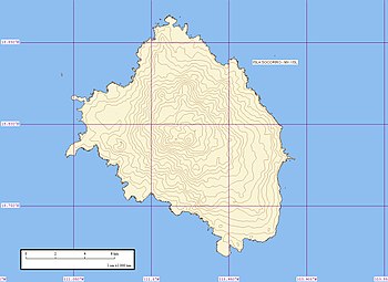
Socorro Island (Spanish: Isla Socorro) is a volcanic island in the Revillagigedo Islands, a Mexican possession lying 600 kilometres (370 mi) off the country's western coast. The size is 16.5 by 11.5 km (10.25 by 7.15 miles), with an area of 132 km (51 sq mi). It is the largest of the four islands of the Revillagigedo Archipelago. The last eruption was in 1993.
Geology

The island rises abruptly from the sea to 1,050 meters (3,440 feet) in elevation at its summit. Socorro Island is the emerged summit of a massive, predominantly submarine shield volcano.
The island is part of the northern Mathematicians Ridge, a mid-ocean ridge that became largely inactive 3.5 million years ago when activity moved to the East Pacific Rise. All four islands along with the many seamounts on the ridge are post-abandonment alkaline volcanoes. Socorro Island is unusual in that it is the only dominantly silicic peralkaline volcanic island in the Pacific Ocean.
It most recently erupted in late January – early February 1993, which was a submarine flank eruption off the coast from Punta Tosca. An earlier eruption was on May 21, 1951; earlier eruptions probably occurred in 1905, 1896 and 1848. The initial volcanic event probably occurred in 3090 BC ±500 years. Mount Evermann (Spanish: Cerro Evermann) is the name given to the summit dome complex, in honor of ichthyologist Barton Warren Evermann. The island's surface is broken by furrows, small craters, and numerous ravines, and covered in lava domes, lava flows and cinder cones.
There are eight bays surrounding Socorro: three on the southern end of island — Vargas Lozano, Braithwaite, and Lucio Gallardo Pavon; Ensenada Grayson on the southwest; Blanca on the northwest with two inlets separated by a rocky outcropping; and North Bay on the island's north end with two inlets separated by a volcanic formation.
There is a naval station, established in 1957, with a population of 250 (staff and families), living in a village with a church, that stands on the western side of Bahía Vargas Lozano, a small cove with a rocky beach, about 800 meters (870 yards) east of Cabo Regla, the southernmost point of the island. The station is served by a dock, a local helipad and Isla Socorro airport, located six kilometers to the north. There is a fresh water spring about 5 kilometers (3.1 miles) northwest of Cabo Regla, at the shoreline of Ensenada Grayson (or Caleta Grayson). This is brackish and sometimes covered by the sea at high tide. In the 1950s, a small freshwater seep was known to exist some 45 meters (49 yards) inland at Bahía Lucio Gallardo Pavon (Binner's Cove), 800 meters (870 yards) northwest of the naval station.
History

No evidence of human habitation on Socorro exists before its discovery by Spanish explorer Hernando de Grijalva and his crew on 19 December 1533, who named it Santo Tomás ("St Thomas Island"; French: Isle St Thomas). In 1542, Ruy López de Villalobos, while exploring new routes across the Pacific, rediscovered Inocentes and renamed it Isla Anublada ("Cloudy Island") due to the clouds frequently forming on the northern slopes of Mount Evermann, and again in 1608, Martín Yañez de Armida, in charge of another expedition, visited Santo Tomás and changed its name to Isla Socorro after Our Lady of Perpetual Help (Virgen del Perpetuo Socorro).
At the beginning of the twentieth century, Barton Warren Evermann, director of the California Academy of Sciences in San Francisco promoted the scientific exploration of the island. The most comprehensive biological collections were obtained at this time. The volcano on Socorro was renamed in his honor.
Archie Smith, an American laborer from San Diego, was marooned on the island for one month in 1929 before being rescued by a passing fishing boat. This was because the expedition that brought him to the island to shear wild sheep returned to port for supplies, but went bankrupt and could not return.
In September 1997, Hurricane Linda passed near the island near peak intensity causing minor damage to meteorological instruments on the island.
Ecology


The lowlands of Socorro – except on the northern, more humid side – are covered with thick shrubland, consisting mainly of endemic Croton masonii and a cactus, probably Engelmann's prickly pear (Opuntia engelmannii). Above 650 metres (2,130 ft) and on the northern side, a richer vegetation occurs. This includes small trees such as Ficus cotinifolia, black cherry (Prunus serotina), and the endemic Guettarda insularis, which bear epiphytic orchids (Epidendrum nitens, E. rigidum and the endemic Pleurothallis unguicallosa).
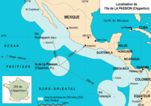
The native land fauna is depauperate, with birds predominating and mammals absent. There is one endemic species of iguanid lizard (Urosaurus auriculatus) and the land crab Johngarthia oceanica, which also occurs on Clipperton Island.
Sheep, cats and rodents were introduced to the island by human activity; more recently, the locust Schistocerca piceifrons has also established itself on the island. Unlike the mammals on Guadalupe Island or Clarión, their impact on the local flora was minor, but cat predation has had a drastic effect since the mid-1970s due to the fauna's island tameness, and the locusts that swarm twice a year seriously damage vegetation during that time. There have been no recorded extinctions of plants on Socorro; several birds have been drastically affected by cat predation however, and one taxon, the Socorro dove, has gone extinct in the wild.
Socorro is an important breeding location for several seabirds, many of which have here one of their north(east)ernmost breeding colonies. The present status of these birds is not well known, and they presumably have suffered from cat predation. In 1953, the following taxa were present:
- Wedge-tailed shearwater, Puffinus pacificus (or Ardenna pacifica)
- Western red-billed tropicbird, Phaethon aethereus mesonauta – breeding suspected but not verified
- Nazca booby, Sula granti – breeding suspected but not verified
- Northeast Pacific brown booby, Sula leucogaster brewsteri – breeding suspected but not verified
- East Pacific great frigatebird, Fregata minor ridgwayi – breeding suspected but not verified; a doubtfully distinct subspecies
- East Pacific sooty tern, Onychoprion fuscatus crissalis – a doubtfully distinct subspecies
- East Pacific brown noddy, Anous stolidus ridgwayi
Non-endemic landbirds and shorebirds occur mostly as vagrants or use the island as a stopover during migration; the northern mockingbird became established in the late 20th century. Among those that are recorded not infrequently are great blue heron, Hudsonian curlew, spotted sandpiper and wandering tattler. Unlike the situation on smaller and more isolated Clarión, wind-blown or vagrant birds seem to constitute the bulk of the recorded species, including brown pelican, osprey, peregrine falcon, semipalmated plover, willet, sanderling, belted kingfisher and buff-bellied pipit. It may be that this puzzling observation is due to the presence of the red-tailed hawks and cats, which has at least made the local Urosaurus more wary than its relative on Clarión, and might deter passing birds from stopping on Socorro.
Endemism
Being the largest of the Revillagigedo Islands and closer to mainland than Clarion, Socorro sports a rich array of endemic taxa, mainly plants and landbirds as well as lizards. Some are threatened due to the presence of feral cats.
Animals

- Socorro parakeet, Aratinga brevipes (endangered)
- Socorro red-tailed hawk, Buteo jamaicensis socorroensis
- Socorro common ground dove, Columbina passerina socorroensis
- Socorro elf owl, Micrathene whitneyi graysoni (probably extinct since c. 1970)
- Socorro mockingbird, Mimodes graysoni (critically endangered)
- Socorro yellow-crowned night heron, Nycticorax violaceus gravirostris (or Nyctanassa violacea gravirostris)
- Socorro tropical parula, Parula pitiayumi graysoni
- Socorro towhee, Pipilo (maculatus) socorroensis
- Townsend's shearwater, Puffinus auricularis (critically endangered; recently extirpated from San Benedicto and probably Clarión)
- Socorro wren, Troglodytes sissonii (near threatened)
- Socorro dove, Zenaida graysoni (extinct in the wild)
- Urosaurus auriculatus (endangered)
Plants
- Acalypha umbrosa
- Aegopogon solisii
- Aristida vaginata
- Aristolochia socorroensis
- Bidens socorrensis
- Botrychium socorrense
- Castilleja socorrensis
- Cestrum pacificum
- Coreocarpus insularis
- Croton masonii
- Erigeron socorrensis
- Eupatorium pacificum
- Guettarda insularis
- Hypericum eastwoodianum
- Ilex socorroensis
- Lantana involucrata var. socorrensis
- Lepechinia hastata ssp. socorrensis
- Meliosma nesites
- Paspalum longum
- Peperomia socorronis
- Physalis mimulus
- Pleurothallis unguicallosa
- Salvia pseudomisella
- Sida nesogena
- Sideroxylon socorrense (Vulnerable)
- Verbena sphaerocarpa
- Vernonia littoralis
Brickellia peninsularis var. amphithalassa, Cheilanthes peninsularis var. insularis, Nicotiana stocktonii, Spermacoce nesiotica and Zapoteca formosa ssp. rosei are near-endemics, being restricted to Socorro and Clarión. Whether Teucrium townsendii ssp. affine is the same plant as those on San Benedicto is not conclusively determined.
Visiting information
Socorro Island is a popular scuba diving destination known for underwater encounters with dolphins, sharks, manta rays and other pelagic animals. Divers visit here on live-aboard dive vessels. The most popular months are between November and May when the weather and seas are calmer. November to December are popular months to visit for a good chance to dive with whale sharks. January and February are popular months to scuba dive with humpback whales as they are then migrating through the Revillagigedo archipelago.
See also
Notes
- Probably ssp. capuli according to biogeography, Brattstrom & Howell (1956) contra CMICD (2007)
References
- "Socorro, Revillagigedo Islands". Britannica. Retrieved 2020-10-08.
- Bohrson, Wendy A.; Reid, Mary R. (1997). "Genesis of Silicic Peralkaline Volcanic Rocks in an Ocean Island Setting by Crustal Melting and Open-system Processes: Socorro Island, Mexico". Journal of Petrology. 38 (9): 1137–1166. doi:10.1093/petroj/38.9.1137.
- "Global Volcanism Program | Report on Socorro (Mexico) — January 1993". volcano.si.edu. doi:10.5479/si.gvp.bgvn199301-341021. Retrieved 2023-05-27.
- "Socorro: Eruptive History". Global Volcanism Program. Smithsonian Institution. Retrieved 2021-06-27.
- "Socorro". Global Volcanism Program. Smithsonian Institution. Retrieved 2021-06-27.
- Mille-Pagaza, Silvia; Pérez-Chi, A.; Sánchez-Salazar, M. E. (2003). "Littoral Decapods of Socorro Island, Revillagigedo Archipelago, Mexico" (PDF). Revista de Biología Tropical. 51 (1): 175–182. ISSN 0034-7744. PMID 15162691.
- "HA06, Socorro Island, Mexico: CTBTO Preparatory Commission". www.ctbto.org. Retrieved 2020-10-08.
- ^ Brattstrom, Bayard H. & Howell, Thomas R. (1956). "The Birds of the Revilla Gigedo Islands, Mexico" (PDF). Condor. 58 (2): 107–120. doi:10.2307/1364977. JSTOR 1364977.
- Brand, Donald D. (1967). Friis, Herman R. (ed.). The Pacific Basin. A History of its Geographical Exploration. New York: American Geographical Society. p. 370.
- American Geographical Society of New York (1967), Special publication, issue 38, p. 370, American Geographical Society, ISSN 0065-843X
- "Socorro Island, Mexico". CTBTO. Retrieved 20 March 2011.
- "Modern Robinson Crusoe Is Rescued from Lonely Island". The Bend Bulletin. 1 July 1929. Retrieved 30 May 2015.
- "Hurricane Linda" (PDF). www.nhc.noaa.gov.
- Perger, Robert (April 2019). "A New Species of Johngarthia from Clipperton and Socorro Islands in the Eastern Pacific Ocean (Crustacea: Decapoda: Gecarcinidae)". Pacific Science. 73 (2): 285–304. doi:10.2984/73.2.9. ISSN 0030-8870. S2CID 146030476.
- ^ BirdLife International (2020). "Mimus graysoni". IUCN Red List of Threatened Species. 2020: e.T22711084A179825007. doi:10.2305/IUCN.UK.2020-3.RLTS.T22711084A179825007.en. Retrieved 12 November 2021.
- BirdLife International (2007): Socorro Dove – BirdLife Species Factsheet. Retrieved 24 November 2007.
- "Socorro Dove (Zenaida graysoni) – BirdLife species factsheet". birdlife.org. 2007. Archived from the original on 2009-01-05. Retrieved 2022-08-16.
- Jehl, Joseph R. Jr.; Parkes, Kenneth C. (1983). "'Replacements' of Landbird Species on Socorro Island, Mexico". The Auk. 100 (3): 551–59. doi:10.1093/auk/100.3.551. S2CID 220333993.
- "Stray pets: Socorro island's endemics and cats". April 13, 2013.
- ^ California/Mexico Island Conservation Database (CMICD, 2007): Plant accounts: Socorro Archived 2007-12-08 at the Wayback Machine. Retrieved 13 November 2007.
- "Diving Socorro in December: Whale Sharks, Manta Rays and Dolphins". Bluewater Dive Travel. 2018-01-09. Retrieved 2019-06-29.
External links
| Eastern Pacific islands | |
|---|---|
| Oceanic islands located between Polynesia and the Americas, sorted by country, from north to south (excluding continental islands) | |
| Mexico | |
| France | |
| Costa Rica | |
| Colombia | |
| Ecuador | |
| Chile | |