Neighborhood of Philadelphia in Pennsylvania, United States
| Kingsessing | |
|---|---|
| Neighborhood of Philadelphia | |
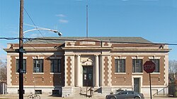
 The Kingsessing Branch of the Free Library of Philadelphia The Kingsessing Branch of the Free Library of Philadelphia | |
 | |
| Coordinates: 39°56′21″N 75°13′18″W / 39.93915°N 75.22165°W / 39.93915; -75.22165 | |
| Country | |
| State | Pennsylvania |
| County | Philadelphia |
| City | Philadelphia |
| Area code(s) | 215, 267, and 445 |
Kingsessing is a neighborhood in the Southwest section of Philadelphia, Pennsylvania, United States. On the west side of the Schuylkill River, it is next to the neighborhoods of Cedar Park and Elmwood Park, as well as the borough of Yeadon in Delaware County. It is roughly bounded by 53rd Street to the northeast, Baltimore Avenue to the northwest, Cobbs Creek and 60th Street to the southwest, and Woodland Avenue to the southeast.
History

The name Kingsessing, also spelled Chinsessing, comes from a Delaware word meaning "a place where there is a meadow". The historic Lenape, or Delaware as the English called them, had a village of the same name that roughly occupied the same site as where the current neighborhood was later developed. When the township was organized to encompass where the Lenape and a later Swedish village stood, it also was named as Kingsessing.
Mount Moriah Cemetery was founded next to Cobbs Creek in 1855. The neighborhood near the cemetery is also known as Mount Moriah, part of which is in Elmwood Park.
In 1669 Hans Månsson, a Swedish settler, received a patent for an 1,100-acre plantation along the Schuylkill River between the current location of 60th Street and Woodlands Cemetery, extending as far west as Cobb's Creek.
Bartram's Garden, started by colonial botanist John Bartram in 1728, is still operated in this neighborhood. It had an international reputation and is considered the first true botanical garden in the United States. It has been designated as a National Historic Landmark.
The S. Weir Mitchell School, Regent-Rennoc Court and Anna Howard Shaw Junior High School are on the National Register of Historic Places.
Demographics
Kingsessing is 83.2% black.
Infrastructure and government
- The United States Postal Service operates the Kingsessing Post Office at 5311 Florence Avenue.
- Grays Ferry Bridge
- 49th Street station (SEPTA Regional Rail)
- Schuylkill River Trail
Education
Public libraries
Free Library of Philadelphia operates the Kingsessing Branch at 1201 South 51st Street, below Chester Avenue.
See also
References
- "Peter Stebbins Craig, "Hans Månsson and his Steelman Family," Swedish Colonial News, Volume 1, Number 10. Fall 1994". Archived from the original on 2009-01-29. Retrieved 2021-11-22.
- "Peter Stebbins Craig, "The 1693 Census of the Swedes on the Delaware: Chapter 3: The Wicaco Congregation," Swedish American Genealogist, vol 10, no 1, March 1990; pp. 1-16".
- Bell, Whitfield J., Jr., Patriot-Improvers: Biographical Sketches of Members of the American Philosophical Society, vol. 1, 1743–1768. APS: Philadelphia, 1997, pp. 3–4.
- "National Register Information System". National Register of Historic Places. National Park Service. July 9, 2010.
- Philadelphia Research Initiative (2011-06-01), A City Transformed: The Racial and Ethnic Changes in Philadelphia Over the Last 20 Years (PDF), p. 12
- "Post Office Location - KINGSESSING." United States Postal Service. Retrieved on December 4, 2008.
- "Kingsessing Branch." Free Library of Philadelphia. Retrieved on November 10, 2008.
- Sources
- Chronology of the Political Subdivisions of the County of Philadelphia, 1683–1854 (Daly, John; Weinberg, Allen (October 1966). Genealogy of Philadelphia County Subdivisions (Second ed.). Philadelphia Dept. of Records.)
- Information courtesy of ushistory.org
- Incorporated District, Boroughs, and Townships in the County of Philadelphia, 1854 By Rudolph J. Walther - excerpted from the book at the ushistory.org website
- 'Row House Days' courtesy of ushistory.org