| Upper North Philadelphia | |
|---|---|
| Neighborhood of Philadelphia | |
 Lillian Marrero Branch of the Philadelphia Free Library is located in Upper North Philadelphia's West Kensington Lillian Marrero Branch of the Philadelphia Free Library is located in Upper North Philadelphia's West Kensington | |
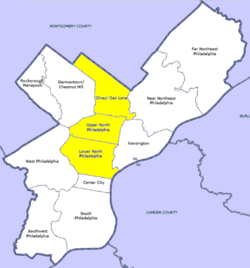
 Map of Philadelphia County with North Philadelphia highlighted. Click for larger image Map of Philadelphia County with North Philadelphia highlighted. Click for larger image | |
| Country | |
| State | |
| County | |
| City | |
| Area | |
| • Total | 44.4 sq mi (115 km) |
| Population | |
| • Total | 181,531 |
| • Density | 12,241/sq mi (4,726/km) |
| ZIP code | 19122, 19132, 19133, 19134, 19140 |
Upper North Philadelphia is a section of Philadelphia that is immediately north of Lower North Philadelphia, and can be described as an area that has a "...large and rapidly growing Puerto Rican population".
According to the planning commission, Upper North Philadelphia officially consists of the Allegheny West, Fairhill, Franklinville, Glenwood, Hunting Park, and Nicetown-Tioga neighborhoods. Bounded by York Street to the south, Front Street to the east, Roosevelt Expressway to the north, and Ridge Avenue to the west.
Demographics
The demographics of Upper North Philadelphia shows that the area has a population density of 12,241 people per mile with an average household size of 3 and 37% of households had children. There is a 17% annual residential turnover rate with 47% of residents staying for more than 5 years, with an average of 6 years of residency. The majority of residents are African Americans and Puerto Ricans.
Racial demographics
- Non-Hispanic Black: 106,559 (58.7%)
- Hispanic or Latino of any race: 62,083 (34.2%)
- Mixed or Other: 4,901 (2.7%)
- Non-Hispanic White: 3,994 (2.2%)
- Asian: 3,990 (2.2%)
References
- Guian A. McKee (15 June 2010). The Problem of Jobs: Liberalism, Race, and Deindustrialization in Philadelphia. ISBN 9780226560144.
- "Upper North Philadelphia, Philadelphia, PA Real Estate Demographics".
- "Factfinder at census.gov". Archived from the original on 2020-02-12. Retrieved 2013-08-24.
- "2010 Census". Medgar Evers College. Archived from the original on 2010-06-11. Retrieved 2010-04-13.
| City of Philadelphia | |
|---|---|
| Topics | |
| Government | |
| Neighborhoods | |
| Museums |
|
| Sports | |
| Squares | |
| Related | |
39°59′08″N 75°09′49″W / 39.98552°N 75.16358°W / 39.98552; -75.16358
Categories: