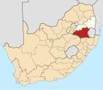
Place in Mpumalanga, South Africa
| Steynsdorp | |
|---|---|
  | |
| Coordinates: 26°07′59″S 30°58′59″E / 26.133°S 30.983°E / -26.133; 30.983 | |
| Country | South Africa |
| Province | Mpumalanga |
| District | Gert Sibande |
| Municipality | Albert Luthuli |
| Area | |
| • Total | 1.14 km (0.44 sq mi) |
| Population | |
| • Total | 585 |
| • Density | 510/km (1,300/sq mi) |
| Racial makeup (2001) | |
| • Black African | 100.0% |
| First languages (2001) | |
| • Swazi | 91.8% |
| • Zulu | 8.2% |
| Time zone | UTC+2 (SAST) |
Steynsdorp, officially eMlondozi, is a settlement in Gert Sibande District Municipality in the Mpumalanga province of South Africa.
It was founded in 1885 and became the centre of the New Paarl goldfield but was abandoned when the Witwatersrand goldfields were discovered.
At first called Painter's Camp, it was named Steynsburg in 1886, after Commandant J P Steyn of Lydenburg. The name was then altered to Steynsdorp to avoid confusion with Steynsburg in the Cape, now Eastern Cape.
References
- ^ "Main Place Steynsdorp". Census 2001.
- "South African Geographical Names Council Act: Official geographical name: Correction" (PDF). www.gov.za. Retrieved 16 December 2024.
- "Dictionary of Southern African Place Names (Public Domain)". Human Science Research Council. p. 415.
| Municipalities and communities of Gert Sibande District Municipality, Mpumalanga | ||
|---|---|---|
| District seat: Ermelo | ||
| Govan Mbeki |  | |
| Albert Luthuli | ||
| Mkhondo | ||
| Msukaligwa | ||
| Lekwa | ||
| Pixley ka Seme | ||
| Dipaleseng | ||
This Mpumalanga location article is a stub. You can help Misplaced Pages by expanding it. |