| Tahirpur তাহিরপুর | |
|---|---|
| Upazila | |
 View of Tanguar Haor View of Tanguar Haor | |
 | |
| Country | |
| Division | Sylhet |
| District | Sunamganj |
| Government | |
| • MP (Sunamganj-1) | Moazzem Hossain Ratan (Awami League) |
| Area | |
| • Total | 315.33 km (121.75 sq mi) |
| Population | |
| • Total | 224,853 |
| • Density | 710/km (1,800/sq mi) |
| Time zone | UTC+6 (BST) |
| Postal code | 3030 |
| Area code | 08732 |
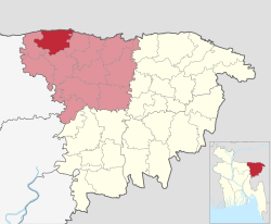
Tahirpur (Bengali: তাহিরপুর) is an upazila of Sunamganj District in the Division of Sylhet, Bangladesh.
Geography
Tahirpur is located at 25°05′30″N 91°10′30″E / 25.0917°N 91.1750°E / 25.0917; 91.1750. It has 42,693 households and total area 315.33 km.
History
The territory of Tahirpur Upazila contains the historic village of Nabagram (in Badaghat Union), which served as the capital of the Laur Kingdom. After the Conquest of Sylhet in 1303, some disciples of warrior-saint Shah Jalal migrated and settled in present-day Tahirpur where they preached Islam to the local people. Most notably, Shah Rafiuddin migrated here and is buried in Sarping on the border with Meghalaya on top of Laur Hill. In the 18th century, Tahirpur became a part of Brajendra Kishore Roy Chowdhury's zamindari based in Gouripur House in Mymensingh. For most of its history, the lower caste Hindus formed the majority of the area's population. During the British Raj, the local council resolved a false accusation against a Bengali Muslim by the name of Tahir Ali. Following this, Tahir Ali settled in this area, renaming it to Tahirpur. Tahirpur was established as a thana in 1924.
During the Bangladesh Liberation War of 1971, a refugee camp was established in Tahirpur on the footsteps of the Khasi and Jaintia Hills. 10 farmers were killed and several arrested during the Bhasan-Pani Movement between 1997 and 1998.
Demographics
| Religions in Tahirpur Upazila (2022) | ||||
|---|---|---|---|---|
| Religion | Percent | |||
| Islam | 93.48% | |||
| Hinduism | 6.22% | |||
| Other or not stated | 0.30% | |||
According to the 2011 Census of Bangladesh, Tahirpur Upazila had 37,931 households and a population of 215,200. 73,148 (33.99%) were under 10 years of age. Tahirpur had a literacy rate (age 7 and over) of 30.40%, compared to the national average of 51.8%, and a sex ratio of 947 females per 1000 males. 9,450 (4.39%) lived in urban areas. Ethnic population was 1,951 (0.91%).
As of the 1991 Bangladesh census, Tahirpur has a population of 155188. Males constitute 51.67% of the population, and females 48.33%. This Upazila's population is 64325. Tahirpur has an average literacy rate of 31.2% (7+ years), and the national average of 30.4% literate.
Administration
Tahirpur has 7 Unions/Wards, 136 Mauzas/Mahallas, and 244 villages. Its unions are North Baradal, Badaghat, North Sripur, Tahirpur Sadar, South Baradal, South Sripur and Balijuri.
Economy
As the saying goes, fish-stone-paddy is the lifeblood of Sunamganj. And one of the suppliers of this fish-stone-paddy is Tahirpur upazila. So, these are one of the sources of economy of this upazila. Boro paddy in Haor in particular is the main source. And after that there are haor fish. Lots of fish are also caught in the river. The sand of Fazilpur of Tahirpur upazila is famous in the country and it is the only limestone mine in the country. In a word, Tahirpur Upazila is famous for its fish, rocks, sand and paddy. Poor people make a living by fishing in rivers, extracting rocks, extracting sand or working in paddy fields. Although agriculture is the main occupation, there is a lot of interest in trade and commerce lately. Basically, due to the real fearlessness of paddy cultivation, the fate of the people of this upazila fluctuates even in the face of water scarcity.
Education
The progress of Tahirpur Upazila in the field of education is very low. There are two colleges in this upazila. A government high school. There are only two girls' high schools. There are also various primary schools, madrasas and other educational systems.
Notable people
- Advaita Acharya (1434-1559), Hindu religious leader
- Maqbul Hossain Choudhury (1898-1957), activist and politician
- Shahed Ali (1925-2001), educationist and activist
- Hassan Shahriar (1946-2021), political analyst and columnist
See also
References
- National Report (PDF). Population and Housing Census 2022. Vol. 1. Dhaka: Bangladesh Bureau of Statistics. November 2023. p. 404. ISBN 978-9844752016.
- "Bangladesh Postal Code". Dhaka: Bangladesh Postal Department under the Department of Posts and Telecommunications of the Ministry of Posts, Telecommunications and Information Technology of the People's Republic of Bangladesh. 20 October 2024.
- "Bangladesh Area Code". Dubai, UAE: My Country Mobile. 18 October 2024.
- ^ Hassan, Muhammad Alomgir (2012). "Tahirpur Upazila". In Sirajul Islam; Miah, Sajahan; Khanam, Mahfuza; Ahmed, Sabbir (eds.). Banglapedia: the National Encyclopedia of Bangladesh (Online ed.). Dhaka, Bangladesh: Banglapedia Trust, Asiatic Society of Bangladesh. ISBN 984-32-0576-6. OCLC 52727562. OL 30677644M. Retrieved 6 January 2025.
- উপজেলার ঐতিহ্য. Tahirpur Upazila (in Bengali).
- তাহিরপুর উপজেলার পটভূমি. Tahirpur Upazila (in Bengali).
- Population and Housing Census 2022 - District Report: Sunamganj (PDF). District Series. Dhaka: Bangladesh Bureau of Statistics. June 2024. ISBN 978-984-475-222-1.
- "Bangladesh Population and Housing Census 2011 Zila Report – Sunamganj" (PDF). bbs.gov.bd. Bangladesh Bureau of Statistics.
- "Community Tables: Sunamganj district" (PDF). bbs.gov.bd. Bangladesh Bureau of Statistics. 2011.
- "Population Census Wing, BBS". Archived from the original on 2005-03-27. Retrieved 10 November 2006.
| Sunamganj District | ||
|---|---|---|
| Capital: Sunamganj | ||
| Upazilas | ||
| Constituencies | ||
| Attractions and sites | ||
| Rivers | ||
| Inhabited areas | ||
| Educational institutions | ||
| Transport | ||
| History | ||
| Capital: Sylhet | ||
| Habiganj District |  | |
| Moulvibazar District | ||
| Sunamganj District | ||
| Sylhet District | ||