You can help expand this article with text translated from the corresponding article in French. (December 2008) Click for important translation instructions.
|
| Tourrette-Levens | |
|---|---|
| Commune | |
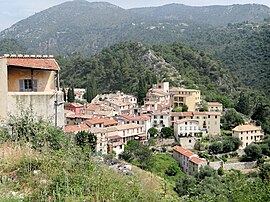
 A view of Tourrette-Levens from the castle A view of Tourrette-Levens from the castle | |
 Coat of arms Coat of arms | |
| Location of Tourrette-Levens | |
  | |
| Coordinates: 43°47′15″N 7°16′36″E / 43.7875°N 7.2767°E / 43.7875; 7.2767 | |
| Country | France |
| Region | Provence-Alpes-Côte d'Azur |
| Department | Alpes-Maritimes |
| Arrondissement | Nice |
| Canton | Tourrette-Levens |
| Intercommunality | Métropole Nice Côte d'Azur |
| Government | |
| • Mayor (2020–2026) | Bertrand Gasiglia |
| Area | 16.5 km (6.4 sq mi) |
| Population | 4,633 |
| • Density | 280/km (730/sq mi) |
| Demonym | Tourrettans |
| Time zone | UTC+01:00 (CET) |
| • Summer (DST) | UTC+02:00 (CEST) |
| INSEE/Postal code | 06147 /06690 |
| Elevation | 160–845 m (525–2,772 ft) (avg. 390 m or 1,280 ft) |
| French Land Register data, which excludes lakes, ponds, glaciers > 1 km (0.386 sq mi or 247 acres) and river estuaries. | |
Tourrette-Levens (French pronunciation: [turɛt ləvɛ̃s]; Occitan: Torreta de Levens; Italian: Torretta Levenzo) is a commune in the Alpes-Maritimes department in southeastern France.
Climate
| Climate data for Tourrette-Levens (2018-2024), altitude: 416 m | |||||||||||||
|---|---|---|---|---|---|---|---|---|---|---|---|---|---|
| Month | Jan | Feb | Mar | Apr | May | Jun | Jul | Aug | Sep | Oct | Nov | Dec | Year |
| Mean daily maximum °C (°F) | 11.4 (52.5) |
13.6 (56.5) |
15.3 (59.5) |
17.4 (63.3) |
21.2 (70.2) |
26.4 (79.5) |
29.9 (85.8) |
30.0 (86.0) |
25.7 (78.3) |
20.3 (68.5) |
14.8 (58.6) |
11.8 (53.2) |
19.8 (67.7) |
| Daily mean °C (°F) | 7.5 (45.5) |
9.2 (48.6) |
10.7 (51.3) |
12.7 (54.9) |
16.4 (61.5) |
21.2 (70.2) |
24.3 (75.7) |
24.6 (76.3) |
20.8 (69.4) |
16.0 (60.8) |
11.2 (52.2) |
8.4 (47.1) |
15.3 (59.5) |
| Mean daily minimum °C (°F) | 3.7 (38.7) |
4.9 (40.8) |
6.1 (43.0) |
8.0 (46.4) |
11.6 (52.9) |
16.0 (60.8) |
18.8 (65.8) |
19.1 (66.4) |
15.9 (60.6) |
12.0 (53.6) |
7.7 (45.9) |
5.1 (41.2) |
10.7 (51.3) |
| Average precipitation mm (inches) | 38.4 (1.51) |
53.5 (2.11) |
62.6 (2.46) |
65.3 (2.57) |
59.0 (2.32) |
35.9 (1.41) |
15.8 (0.62) |
20.4 (0.80) |
32.4 (1.28) |
96.0 (3.78) |
96.1 (3.78) |
97.2 (3.83) |
672.6 (26.47) |
| Average precipitation days (≥ 1 mm) | 2.8 | 3.8 | 4.6 | 7.2 | 6.3 | 4.2 | 2.8 | 2.3 | 4.3 | 7.5 | 8.5 | 6.7 | 61 |
| Mean monthly sunshine hours | 102.9 | 121.7 | 151.5 | 146.4 | 148.7 | 157.1 | 178.0 | 149.0 | 139.0 | 99.6 | 75.5 | 68.7 | 1,538.1 |
| Source: Infoclimat | |||||||||||||
Population
| Year | Pop. | ±% p.a. |
|---|---|---|
| 1968 | 2,650 | — |
| 1975 | 2,644 | −0.03% |
| 1982 | 3,004 | +1.84% |
| 1990 | 3,412 | +1.60% |
| 1999 | 4,116 | +2.11% |
| 2007 | 4,709 | +1.70% |
| 2012 | 4,786 | +0.32% |
| 2017 | 4,951 | +0.68% |
| Source: INSEE | ||
Tourism
Tourrette-Levens is one of sixteen villages grouped together by the Métropole Nice Côte d'Azur tourist department as the Route des Villages Perchés (Route of Perched Villages). The others are: Aspremont, Carros, Castagniers, Coaraze, Colomars, Duranus, Èze, Falicon, La Gaude, Lantosque, Levens, La Roquette-sur-Var, Saint-Blaise, Saint-Jeannet and Utelle.
See also
References
- "Répertoire national des élus: les maires". data.gouv.fr, Plateforme ouverte des données publiques françaises (in French). 2 December 2020.
- "Populations de référence 2022" (in French). The National Institute of Statistics and Economic Studies. 19 December 2024.
- Commune de Tourrette-Levens (06147), INSEE
- "Tourrette-Levens: Occurences de phénomènes". Infoclimat (in French). Retrieved 16 August 2024.
- "Normales et records pour la période 2001-2030 à Tourrette-Levens: Valeurs climatologiques". Infoclimat (in French). Retrieved 16 August 2024.
43.78°N, 7.43°E
- Population en historique depuis 1968, INSEE
- "The route of perched villages" (PDF). Métropole Nice Côte d'Azur. 2013.
This Alpes-Maritimes geographical article is a stub. You can help Misplaced Pages by expanding it. |