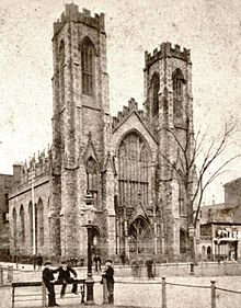
University Place is a short north-south thoroughfare in the Greenwich Village neighborhood of Manhattan, New York City, United States, which runs from Washington Square Park in the south as a continuation of Washington Square East, taking the position of Madison Avenue uptown, and terminates at East 14th Street just southwest of Union Square. Although the roadway continues north of 14th Street as Union Square West, traffic on the two streets run in opposite directions (University Place uptown, and Union Square West downtown), both feeding into 14th Street. Until the late 1990s, University Place was a two-way street. The street contains numerous cafes, shops, and restaurants, many of which cater to students at NYU and The New School.
History
University Place was formerly part of Wooster Street, but received a new name in 1838, a year after New York University's first building opened on Washington Square. The street was the original location of the Union Theological Seminary in 1838, and the New York Society Library moved there in 1856. The Industrial Education Association, precursor to Teachers College, occupied the Union Theological Seminary building in the late 1880s.
See also
- Buegeleisen and Jacobson, musical instrument distributor
References
- Richards, T.A. (1860). Appleton's Illustrated Hand-book of American Travel: A Full and Reliable Guide to the United States and the British Provinces by T.A. Richards. Collections spéciales. Appleton. p. 114. Retrieved November 28, 2019.
- Lamb, M.J.; Harrison, B. (1896). History of the City of New York: Its Origin, Rise and Progress. A. S. Barnes. p. 720. Retrieved November 28, 2019.
- "A Mysterious Burglary" (PDF). The New York Times. August 20, 1879.
- More on Mancius Smede Hutton can be found in Corwin, Edward Tanjore (1902). A Manual of the Reformed Church in America (formerly Ref. Prot. Dutch Church). 1628-1902. Board of publication of the Reformed church in America. p. 537. ISBN 9780524060162. Retrieved November 28, 2019.
- Moscow, Henry (1978). The Street Book: An Encyclopedia of Manhattan's Street Names and Their Origins. New York: Hagstrom Company. p. 10. ISBN 978-0-8232-1275-0.
- Burrows, Edwin G. and Wallace, Mike (1999). Gotham: A History of New York City to 1898. New York: Oxford University Press. pp. 531, 782. ISBN 0-195-11634-8.
- Dolkart, Andrew S. (1998). Morningside Heights: A History of its Architecture and Development. New York: Columbia University Press. p. 226. ISBN 978-0-231-07850-4. OCLC 37843816.
| Union Square | |||||
|---|---|---|---|---|---|
| Manhattan, New York City | |||||
| Art |
| ||||
| Historical |
| ||||
| Buildings |
| ||||
| Transportation | |||||
| Streets of Manhattan | |||||||||||||||||
|---|---|---|---|---|---|---|---|---|---|---|---|---|---|---|---|---|---|
| North–south |
| ||||||||||||||||
| East–west |
| ||||||||||||||||
| Intersections |
| ||||||||||||||||
| |||||||||||||||||
40°43′57.07″N 73°59′38.41″W / 40.7325194°N 73.9940028°W / 40.7325194; -73.9940028
Categories: