Municipality In Kochi in India
| Kalamassery | |
|---|---|
| Municipality In Kochi | |
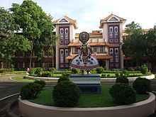
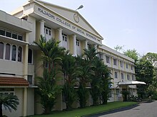
    Clockwise from top: Administrative office of CUSAT, Toyota office, Kalamassery metro station, National University of Advanced Legal Studies Clockwise from top: Administrative office of CUSAT, Toyota office, Kalamassery metro station, National University of Advanced Legal Studies | |
  | |
| Coordinates: 10°03′07″N 76°18′57″E / 10.0519694°N 76.3157719°E / 10.0519694; 76.3157719 | |
| Country | |
| City UA | Kochi |
| State | Kerala |
| District | Ernakulam |
| Government | |
| • Type | Municipal Council |
| • Body | Kalamassery Municipality |
| Area | |
| • Total | 27 km (10 sq mi) |
| Population | |
| • Total | 70,776 |
| • Density | 2,600/km (6,800/sq mi) |
| Languages | |
| • Official | Malayalam and English |
| Time zone | UTC+5:30 (IST) |
| PIN | 683 503,683 104 |
| Vehicle registration | KL-07 |
| Website | www |
Kalamassery ([kɐɭɐmɐʃːeːɾi]) is a municipality in the Ernakulam district of Kerala, India. It is a prominent industrial region in the Kochi metropolitan area, and is located 9 km (5.6 mi) northeast of the Kochi city centre. As per the 2011 Indian census, Kalamassery had a population of 70,776 people, and a population density of 2,621/km (6,790/sq mi).
Kalamassery is a major hub for industrial and IT activities in Kochi. The Kalamassery Industrial Estate set up by the Government of Kerala is home to many major companies. Kalamassery is also home to educational institutions such as the National University of Advanced Legal Studies, Ernakulam Medical College, and the Cochin University of Science and Technology. The area's location along the NH 66 and proximity to the IT centres in Kakkanad has enabled it to see a large spurt in economic development since the 1980s.
Etymology
The name Kalamassery is derived from Kalabhasery. In Malayalam, a word can have multiple meanings: in common usage "kalabham" means yellow sandalwood paste, and in literary Malayalam, it can mean Elephant. Kalabhasery, a location near HMT, was where elephants from Thrikkakara Temple was taken for rest after celebrations at the temple. During the course of time Kalabhasery became Kalamassery. Historically, the prominent area was called Njalakam, place with a prominent Juma Masjid, but during the time of creation of Kalamassery Panchayat which includes Njalakam, it was decided to name the area Kalamassery instead of Njalakam due to the growth of Kalamassery. A primary driver of growth was the nearby Fertilisers and Chemicals Travancore Limited (FACT) in Udyogamandal. Employees of FACT would regularly visit Kalamassery for shopping and other purposes. Many settled down in Kalamassery after retirement in places like Santhinagar and Santhinagar Annexe. This growth was brought about by new industries like HMT in that area. Later, the rapid growth of Kalamassery led to it being promoted to a Municipality.
Geography
The soils consists mainly of recent sediments (Alluvium, Teri's, Brown sand etc.). Red colored sticky soil is also found in these areas. The climate is generally tropical, heavy rains from the southwest and northeast monsoon are common from June through September. The average annual rainfall is about 350 cm.
Demographics
| Year | Pop. | ±% |
|---|---|---|
| 1991 | 54,342 | — |
| 2001 | 63,176 | +16.3% |
| 2011 | 71,038 | +12.4% |
| Source: | ||
As of 2001 India census, Kalamassery had a population of 63,176. Sex ratio is 956 females per 1000 males. Kalamassery has an average literacy rate of 84%, which is significantly higher than the national average of 59.5%. Male literacy is 87%, and female literacy is 82%. In Kalamassery, 10% of the population is under 6 years of age. Hinduism is the most professed religion at 41%, followed by Islam (34%).
| Graphs are unavailable due to technical issues. Updates on reimplementing the Graph extension, which will be known as the Chart extension, can be found on Phabricator and on MediaWiki.org. |
Economy

FACT, India's 1st large scale unit was set up in 1943 for production of fertiliser. In 1947, FACT Udyogamandal started production of ammonium sulphate with an installed capacity of 10,000 MT nitrogen. FACT became a Kerala State Public Sector Enterprise on 15 August 1960 and on 21 November 1962; the Government of India became a major Shareholder. FACT engineering works was established on 13 April 1966. Aluminium oxide is also produced in Kalamassery. Apollo Tyres acquired the Premier Tyres plant in Kalamassery. The Hindustan Machine Tools also known as HMT is also located at the hearts of Kalamassery . Merchem and Carborundum Universal Electro-minerals division has its offices at South Kalamassery. Many Vehicle aftersales - service centres like Toyota, Renault, Nissan, Volkswagen, Fiat India Automobiles etc., are located at Kalamassery. The Kerala State Electricity Board or KSEB sub-division is at Kalamassery . The Kochi Metro Casting Yard and Metro Village is located at HMT Colony in Kalamassery . The Science City, Startup Village, KINFRA are at Kalamassery. The Water from Periyar is supplied to Kochi City by Various pipes placed which are managed by the PWD and the Kerala Water Authority. India's first telecom incubation center located in kalamassery.
There are also many small scale industries in Kalamassery like St Antony Industries, Micro Tools, Ambadan Industries, Vellappally Manufacturing Industry, Pottekattu Rubbers Pvt. Ltd, Logiwiz, Bajaj etc. A part of South Kalamassery is as an Industrial area, with small scale industries such as perfume making industries and plastic recycling industries. Many people are engaged in employment through these industries. There are also Kudumbasree associations, employing many women. The Main Headquarters of Vodafone India is at South Kalamassery. The largest shopping mall in India- LuLu International Shopping Mall started in 2013 is at Edapally toll, which is a part of Kalamasserry Municipality.
Kalamassery is home to 3 Kochi Metro stations:
- The Kalamassery Town metro station is located at the Premier Junction in Kalamassery, in front of the Apollo Tyres factory.
- The CUSAT metro station, which is located close to Cochin University of Science and Technology in South Kalamassery.
- The Pathadipalam metro station, located near MILMA, ERCMPU LTD in Koonamthai.

| |||||||||||||||||||
Places of interest
Museum of Kerala History
Museum of Kerala History is situated near Pathadippalam Metro Station. It has representations of 87 figures who shaped the history and culture of Kerala in the last two thousand years. The museum has a collection of 150 dolls, all hand-made and detailed, representing the cultural and ethnic diversity of India. The dolls represent young men and women from Gujarat to Nagaland and from Kashmir to Kanyakumari. The gallery depicts mainly specimens of Indian contemporary art (painting and sculpture) over a period of the last two hundred years. The gallery also displays a mural painting based on the classical Sanskrit drama Shakuntalam executed in the traditional Kerala. The mural, at 25 feet long and 5 feet wide, is one of the largest in Kerala.
Kochi Science City
The Science Park is a project of the Kerala government and is located near the Government Medical College, Kalamassery. It houses various attractions for children including an amphitheatre and a planetarium.
Education
 Rajagiri Public School
 SCMS School of Management
 Rajagiri College of Social Science
- Government Medical College Ernakulam
- National University of Advanced Legal Studies
- Cochin University of Science and Technology
- Model Engineering College
- St. Paul’s College
- Xavier Institute of Management and Entrepreneurship
- LBS Centre for Science & Technology
- Rajagiri College of Social Sciences
- Government Polytechnic College
- Little Flower Engineering Institute
- Government I.T.I Kalamassery
- Food Craft Institute
Places of worship
- St. John of God Roman Catholic Church, Angel Mary Nagar, Kalamassery.
- Thrikkakkara Vamana Moorthy Temple
- SNDP Temple, Kangarappady
- Peringazha Sree Durga Bhagavati Temple
- Korakkambilly Sri Durgabhavathi
- St. Pius Xth Church, Kalamassery
- Ponnakudam Bhagavathy Temple
- Puthuserymala Sri Bhadrakali Temple
- Vidakkuzha Sree Krishna Swami Temple
- Kavungalkavu Durga Temple
- Jnanasidhi Ayyappa Temple
- Kudilil Sree Kurumba Bhagavathi Temple
- Puthalath Devi Temple
- St. George Orthodox Church, Seaport Airport Road, Kalamassery
- Njalakam Juma Masjid, South Kalamassery
- Hayathul Islam Masjid, Changampuzha Nagar
- Kalamassery Mahaganapathy Temple
- St. Thomas Marthoma Church Kalamassery
- All Saints CSI Church
- St Marys Jacobite Church
- St Jude Knayana Church
- Kavungal Kaavu Shri Durga Bhagavathi Temple Pallilamkara
- Ibrahim Masjid, Mannopilly
- Hidayathul Islam Masjid, Changampuzha Nagar
- St. Joseph's Church Kalamassery (Social Church)
See also
References
- https://lsgkerala.gov.in/system/files/2017-10/localbodies.pdf
- https://lsgkerala.gov.in/system/files/2017-10/localbodies.pdf
- https://www.kdpia.com/
- "Kalamassery's potential remains untapped". The Times of India. 7 January 2019.
- "Multiple meaning for kalabham". Retrieved 11 September 2015.
- "Njalakam Juma Masjid, Kalamassery". Retrieved 11 September 2015.
- Office of the Registrar General and Census Commissioner (web), Delimitation Commission of India (web), Rand McNally International Atlas 1994, School of Planning & Architecture (web).
- "Census of India 2001: Data from the 2001 Census, including cities, villages and towns (Provisional)". Census Commission of India. Archived from the original on 16 June 2004. Retrieved 1 November 2008.
- Kumar, A. Suresh; Nair, E. N. Muraleedharan; Babu, N. R. S. (1992). An Information guide to Kerala's industrial scenario 1992: towards industrial thought & action. Arya Fine Arts. Retrieved 23 March 2012.
- Business World. Ananda Bazar Patrika Ltd. October 1996. p. 151. Retrieved 23 March 2012.
- "Basic Services To The Urban Poor (BSUP)". Kudumbashree.org. Retrieved 23 March 2012.
- "Biggest shopping mall in India opens in Kochi". Archived from the original on 15 March 2013.
- "India Heritage Walk Festival".
- ^ "Dolls Museum". Artandkeralahistory.org. Retrieved 23 March 2012.
| Neighbourhoods of Kochi | |
|---|---|
|
| Populated places in Ernakulam district | |||||||||||||||
|---|---|---|---|---|---|---|---|---|---|---|---|---|---|---|---|
| Cities and towns |
| ||||||||||||||
| Sub-districts and villages |
| ||||||||||||||