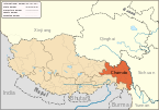
| Zogang County 左贡县 • མཛོ་སྒང་རྫོང་། | |
|---|---|
| County | |
 Location of Zogang County within Tibet Autonomous Region Location of Zogang County within Tibet Autonomous Region | |
  | |
| Coordinates: 29°40′26″N 97°50′24″E / 29.67389°N 97.84000°E / 29.67389; 97.84000 | |
| Country | China |
| Autonomous region | Tibet |
| Prefecture-level city | Chamdo |
| County seat | Uyak |
| Area | |
| • Total | 11,839.8 km (4,571.4 sq mi) |
| Population | |
| • Total | 46,608 |
| • Density | 3.9/km (10/sq mi) |
| Time zone | UTC+8 (China Standard) |
| Website | zuogong |
| Zogang County | |||||||
|---|---|---|---|---|---|---|---|
| Chinese name | |||||||
| Simplified Chinese | 左贡县 | ||||||
| Traditional Chinese | 左貢縣 | ||||||
| |||||||
| Tibetan name | |||||||
| Tibetan | མཛོ་སྒང་རྫོང་། | ||||||
| |||||||
Zogong County (Tibetan: མཛོ་སྒང་རྫོང་; Chinese: 左贡县) is a county of the Chamdo Prefecture in the Tibet Autonomous Region, China,
Administrative divisions
Zogong County is divided in 3 towns and 7 townships.
| Name | Chinese | Hanyu Pinyin | Tibetan | Wylie | ||
|---|---|---|---|---|---|---|
| Town | ||||||
| Uyak Town | 旺达镇 | Wàngdá zhèn | དབུ་ཡག་གྲོང་རྡལ། | dbu yag grong rdal | ||
| Temtok Town | 田妥镇 | Tiántuǒ zhèn | ཐེམ་ཐོག་གྲོང་རྡལ། | them thog grong rdal | ||
| Oktang Town | 扎玉镇 | Zhāyù zhèn | འོག་ཐང་གྲོང་རྡལ། | 'og thang grong rdal | ||
| Townships | ||||||
| Dobbar Township | 东坝乡 | Dōngbà xiāng | སྟོབས་འབར་ཤང་། | stobs 'bar shang | ||
| Rigo Township | 仁果乡 | Rénguǒ xiāng | རི་མགོ་ཤང་། | ri mgo shang | ||
| Rabchen Township | 绕金乡 | Ràojīn xiāng | རབ་ཆེན་ཤང་། | rab chen shang | ||
| Pütog Township | 碧土乡 | Bìtǔ xiāng | བུལ་ཐོག་ཤང་། | bul thog shang | ||
| Maiyü Township | 美玉乡 | Měiyù xiāng | སྨད་ཡུལ་ཤང་། | smad yul shang | ||
| Zhonglingka Township (Zhong Lingka) |
中林卡乡 | Zhōnglínkǎ xiāng | ཀྲུང་གླིང་ཁ་ཤང་། | krung gling kha shang | ||
| Zhalingkha Township | 下林卡乡 | Xiàlínkǎ xiāng | ཞྭ་གླིང་ཁ་ཤང་། | zhwa gling kha shang | ||
Climate
| Climate data for Zogang, elevation 3,780 m (12,400 ft), (1991–2020 normals, extremes 1981–2010) | |||||||||||||
|---|---|---|---|---|---|---|---|---|---|---|---|---|---|
| Month | Jan | Feb | Mar | Apr | May | Jun | Jul | Aug | Sep | Oct | Nov | Dec | Year |
| Record high °C (°F) | 17.2 (63.0) |
15.9 (60.6) |
21.6 (70.9) |
22.2 (72.0) |
25.0 (77.0) |
26.3 (79.3) |
27.9 (82.2) |
25.4 (77.7) |
24.7 (76.5) |
22.0 (71.6) |
17.4 (63.3) |
15.3 (59.5) |
27.9 (82.2) |
| Mean daily maximum °C (°F) | 4.7 (40.5) |
6.6 (43.9) |
9.3 (48.7) |
12.7 (54.9) |
17.0 (62.6) |
20.6 (69.1) |
20.2 (68.4) |
19.8 (67.6) |
18.5 (65.3) |
14.6 (58.3) |
9.7 (49.5) |
5.9 (42.6) |
13.3 (56.0) |
| Daily mean °C (°F) | −4.6 (23.7) |
−2.2 (28.0) |
1.2 (34.2) |
4.8 (40.6) |
9.2 (48.6) |
13.3 (55.9) |
13.3 (55.9) |
12.6 (54.7) |
11.0 (51.8) |
6.2 (43.2) |
0.2 (32.4) |
−4.0 (24.8) |
5.1 (41.2) |
| Mean daily minimum °C (°F) | −12.1 (10.2) |
−9.5 (14.9) |
−5.2 (22.6) |
−1.1 (30.0) |
3.1 (37.6) |
7.8 (46.0) |
8.7 (47.7) |
8.1 (46.6) |
5.9 (42.6) |
0.3 (32.5) |
−6.6 (20.1) |
−11.3 (11.7) |
−1.0 (30.2) |
| Record low °C (°F) | −23.0 (−9.4) |
−19.1 (−2.4) |
−17.8 (0.0) |
−11.4 (11.5) |
−8.0 (17.6) |
−1.8 (28.8) |
0.6 (33.1) |
1.2 (34.2) |
−1.7 (28.9) |
−10.3 (13.5) |
−16.7 (1.9) |
−22.7 (−8.9) |
−23.0 (−9.4) |
| Average precipitation mm (inches) | 0.8 (0.03) |
2.4 (0.09) |
9.5 (0.37) |
17.9 (0.70) |
29.9 (1.18) |
62.2 (2.45) |
139.3 (5.48) |
115.5 (4.55) |
61.3 (2.41) |
14.8 (0.58) |
4.4 (0.17) |
1.4 (0.06) |
459.4 (18.07) |
| Average precipitation days (≥ 0.1 mm) | 1.7 | 2.5 | 5.5 | 8.0 | 8.4 | 13.1 | 20.8 | 20.5 | 12.6 | 4.9 | 2.6 | 1.6 | 102.2 |
| Average snowy days | 3.9 | 5.7 | 10.3 | 11.2 | 3.4 | 0.2 | 0.1 | 0 | 0.5 | 3.9 | 4.5 | 2.7 | 46.4 |
| Average relative humidity (%) | 44 | 44 | 46 | 50 | 51 | 56 | 68 | 70 | 67 | 56 | 50 | 47 | 54 |
| Mean monthly sunshine hours | 184.0 | 181.6 | 211.9 | 204.4 | 215.1 | 189.8 | 156.2 | 158.3 | 166.6 | 189.3 | 180.7 | 180.4 | 2,218.3 |
| Percent possible sunshine | 57 | 57 | 57 | 53 | 51 | 45 | 37 | 39 | 46 | 54 | 57 | 57 | 51 |
| Source: China Meteorological Administration | |||||||||||||
Transportation

References
- "昌都市第七次全国人口普查主要数据公报" (in Chinese). Government of Chamdo. 2021-06-22.
- 中国气象数据网 – WeatherBk Data (in Simplified Chinese). China Meteorological Administration. Retrieved 27 August 2023.
- 中国气象数据网 (in Simplified Chinese). China Meteorological Administration. Retrieved 27 August 2023.
| County-level divisions of Tibet Autonomous Region | |||||||||||||
|---|---|---|---|---|---|---|---|---|---|---|---|---|---|
| Lhasa (capital) | |||||||||||||
| Prefecture-level cities |
| ||||||||||||
| Prefecture |
| ||||||||||||
| ** Southern portions of these counties are claimed by the People's Republic of China as part of the South Tibet area, but are administered by India. | |||||||||||||
| Chamdo | ||||||
|---|---|---|---|---|---|---|
| County-level divisions |
|  | ||||
| Settlements | ||||||
| Sciences | ||||||
| Cultures | ||||||
This Chamdo, Tibet location article is a stub. You can help Misplaced Pages by expanding it. |