This is an old revision of this page, as edited by CrnoBelo (talk | contribs) at 17:13, 3 September 2012. The present address (URL) is a permanent link to this revision, which may differ significantly from the current revision.
Revision as of 17:13, 3 September 2012 by CrnoBelo (talk | contribs)(diff) ← Previous revision | Latest revision (diff) | Newer revision → (diff) Place in Vojvodina, Serbia| Vajska Вајска | |
|---|---|
| Country | |
| Province | |
| Municipality | Bač |
| Population | |
| • Total | 3,169 |
| Time zone | UTC+1 (CET) |
| • Summer (DST) | UTC+2 (CEST) |

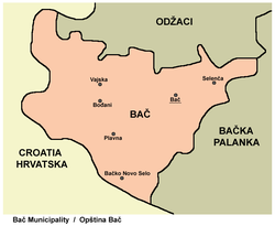
Vajska (Serbian Cyrillic: Вајска listen) is a village in Serbia. It is situated in the Bač municipality, in the South Bačka District, Vojvodina province. Two neighbouring settlements, Labudnjača and Živa, are also officially regarded as parts of Vajska although they are physycally separated from it.
Name
In Serbian the village is known as Vajska (Вајска), in Croatian as Vajska, in Hungarian as Vajszka or Józsefháza, and in German as Wajska.
Demographics
The population of the village numbering 3,169 people (2002 census), including 1,319 Serbs, 569 Romanians, 353 Croats, 341 Hungarians, 207 Yugoslavs, and others.
Historical population
- 1961: 4,355
- 1971: 3,798
- 1981: 3,448
- 1991: 3,272
Galllery
See also
References
- Slobodan Ćurčić, Broj stanovnika Vojvodine, Novi Sad, 1996.
| Cities, towns and villages in the South Bačka District | |
|---|---|
| Seat of the district: Novi Sad | |
| Novi Sad | |
| Petrovaradin | |
| Bač | |
| Bačka Palanka | |
| Bački Petrovac | |
| Bečej | |
| Beočin | |
| Srbobran | |
| Sremski Karlovci |
|
| Temerin | |
| Titel | |
| Vrbas | |
| Žabalj | |
| (*) bold are municipalities or cities, 1 - Novi Sad`s urban municipalities, which aren't fully formed | |
45°25′N 19°07′E / 45.417°N 19.117°E / 45.417; 19.117
This South Bačka District, Vojvodina location article is a stub. You can help Misplaced Pages by expanding it. |
