| Ababuj | |
|---|---|
 | |
 Coat of arms Coat of arms | |
  | |
| Coordinates: 40°33′N 0°48′W / 40.550°N 0.800°W / 40.550; -0.800 | |
| Country | |
| Autonomous community | |
| Province | Teruel |
| Comarca | Comunidad de Teruel |
| Area | |
| • Total | 54.30 km (20.97 sq mi) |
| Elevation | 1,368 m (4,488 ft) |
| Population | |
| • Total | 76 |
| • Density | 1.4/km (3.6/sq mi) |
| Time zone | UTC+1 (CET) |
| • Summer (DST) | UTC+2 (CEST) |
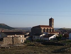
Ababuj (Spanish pronunciation: [abaˈbux]) is a municipality located in the Comunidad de Teruel comarca, province of Teruel, Aragon, Spain. According to the 2010 census the municipality had a population of 77 inhabitants. Its postal code is 44155.
The town is located at high elevation between the Sierra del Pobo and Sierra de Gúdar, part of the Sistema Ibérico.
See also
References
- Municipal Register of Spain 2018. National Statistics Institute.
- Instituto Nacional de Estadística (Spain)
External links
This article about a location in the Province of Teruel is a stub. You can help Misplaced Pages by expanding it. |