| This article needs additional citations for verification. Please help improve this article by adding citations to reliable sources. Unsourced material may be challenged and removed. Find sources: "Estercuel" – news · newspapers · books · scholar · JSTOR (April 2024) (Learn how and when to remove this message) |
| Estercuel | |
|---|---|
| municipality | |
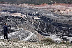
 Coal mine in Estercuel Coal mine in Estercuel | |
 Flag Flag Coat of arms Coat of arms | |
 | |
| Coordinates: 40°51′N 0°38′W / 40.850°N 0.633°W / 40.850; -0.633 | |
| Country | Spain |
| Autonomous community | Aragon |
| Province | Teruel |
| Area | |
| • Total | 55 km (21 sq mi) |
| Elevation | 829 m (2,720 ft) |
| Population | |
| • Total | 210 |
| • Density | 3.8/km (9.9/sq mi) |
| Time zone | UTC+1 (CET) |
| • Summer (DST) | UTC+2 (CEST) |
Estercuel is a municipality located in the province of Teruel, Aragon, Spain. According to the 2004 census (INE), the municipality has a population of 314 inhabitants.
Geography
The municipality is situated at an altitude of 829 m (2,720 ft) above sea level, it has an area of 55.9 km (21.6 sq mi). The distance by road to Teruel is 120 kilometres (75 mi). It can be accessed by the N-420 / N-211. The town is located at the foothills of the Sierra de San Just, and not far from the Sierra de los Moros. The town is to the left of the Estercuel river, also called Zarzosa.
References
- Municipal Register of Spain 2018. National Statistics Institute.
External links
- Government of Aragon Geographic Data (in Spanish)
This article about a location in the Province of Teruel is a stub. You can help Misplaced Pages by expanding it. |