Commune in Nouvelle-Aquitaine, France
| This article needs additional citations for verification. Please help improve this article by adding citations to reliable sources. Unsourced material may be challenged and removed. Find sources: "Châtelus-le-Marcheix" – news · newspapers · books · scholar · JSTOR (April 2018) (Learn how and when to remove this message) |
| Châtelus-le-Marcheix | |
|---|---|
| Commune | |
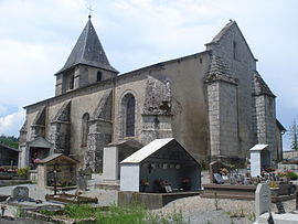
 The church in Châtelus-le-Marcheix The church in Châtelus-le-Marcheix | |
| Location of Châtelus-le-Marcheix | |
  | |
| Coordinates: 46°00′01″N 1°36′31″E / 46.0003°N 1.6086°E / 46.0003; 1.6086 | |
| Country | France |
| Region | Nouvelle-Aquitaine |
| Department | Creuse |
| Arrondissement | Guéret |
| Canton | Le Grand-Bourg |
| Intercommunality | CC Bénévent-Grand-Bourg |
| Government | |
| • Mayor (2022–2026) | Philippe Riot |
| Area | 43.2 km (16.7 sq mi) |
| Population | 310 |
| • Density | 7.2/km (19/sq mi) |
| Time zone | UTC+01:00 (CET) |
| • Summer (DST) | UTC+02:00 (CEST) |
| INSEE/Postal code | 23056 /23430 |
| Elevation | 294–650 m (965–2,133 ft) |
| French Land Register data, which excludes lakes, ponds, glaciers > 1 km (0.386 sq mi or 247 acres) and river estuaries. | |
Châtelus-le-Marcheix (French pronunciation: [ʃatly lə maʁʃɛ]; Occitan: Chasteluç lo Marchès) is a commune in the Creuse department in the Nouvelle-Aquitaine region in central France.
Geography
A village of farming, forestry, lakes and streams situated some 22 miles (35 km) southwest of Guéret by the banks of the Taurion river and at the junction of the D5, D8 and the D48 roads. The village lies on the pilgrimage path of the Way of St. James.
Population
| Year | Pop. | ±% |
|---|---|---|
| 1962 | 500 | — |
| 1968 | 647 | +29.4% |
| 1975 | 495 | −23.5% |
| 1982 | 447 | −9.7% |
| 1990 | 375 | −16.1% |
| 1999 | 356 | −5.1% |
| 2008 | 365 | +2.5% |
Personalities
- Pierre Michon, writer, was born here in 1945.
Sights
- The church, dating from the fourteenth century.
- Ruins of a feudal castle.
See also
References
- "Répertoire national des élus: les maires" (in French). data.gouv.fr, Plateforme ouverte des données publiques françaises. 4 May 2022.
- "Populations de référence 2022" (in French). The National Institute of Statistics and Economic Studies. 19 December 2024.
External links
This Creuse geographical article is a stub. You can help Misplaced Pages by expanding it. |