| This article needs additional citations for verification. Please help improve this article by adding citations to reliable sources. Unsourced material may be challenged and removed. Find sources: "Faraony River" – news · newspapers · books · scholar · JSTOR (February 2024) (Learn how and when to remove this message) |
| Faraony River | |
|---|---|
 | |
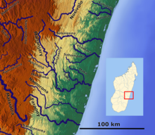
 Map of Malagasy rivers (Faraony flows from the central part to the eastern coast). Map of Malagasy rivers (Faraony flows from the central part to the eastern coast). | |
| Location | |
| Country | Madagascar |
| Region | Fitovinany |
| City | Ampasimanjeva |
| Physical characteristics | |
| Mouth | |
| • location | Indian Ocean |
| • coordinates | 21°48′09″S 48°09′58″E / 21.80250°S 48.16611°E / -21.80250; 48.16611 |
| • elevation | 0m |
| Length | 150 km (93 mi) |
| Basin size | 2,695 km (1,041 sq mi) to 2,776 km (1,072 sq mi) |
| Discharge | |
| • location | Near mouth |
| • average | (Period: 1971–2000)77.1 m/s (2,720 cu ft/s) |
| Basin features | |
| River system | Faraony River |
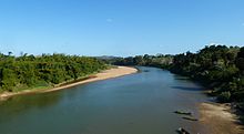
Faraony is a river in Fitovinany, eastern Madagascar. It flows down from the central highlands to the Indian Ocean. It flows through Manampatrana, Vohimanitra, Mahabako, Sahasinaka, Mahavoky, Vohimasina Nord and empties south of Namorona in the Indian Ocean.


References
- ^ "Madagascar".
This article related to a river in Madagascar is a stub. You can help Misplaced Pages by expanding it. |