| Menarandra River | |
|---|---|
 | |
| Location | |
| Country | Madagascar |
| Region | Atsimo-Andrefana, Anosy |
| Cities | Tranoroa, Riambe, Vohitovoa, Morafeno Bekily |
| Physical characteristics | |
| Source | |
| • location | west of Isoanala, Tsikoriky massif |
| • elevation | 600 m (2,000 ft) |
| Mouth | Indian Ocean |
| • location | near Bevoalavo Est, Anosy |
| • coordinates | 25°16′40″S 44°29′40″E / 25.27778°S 44.49444°E / -25.27778; 44.49444 |
| • elevation | 0 m (0 ft) |
| Length | 235 km (146 mi) |
| Basin size | 8,350 km (3,220 sq mi) |
| Basin features | |
| Tributaries | |
| • left | Manantanana River at Bekily, Menakompy River, 30 km south of Bekily, Ivovoky |
| This article does not cite any sources. Please help improve this article by adding citations to reliable sources. Unsourced material may be challenged and removed. Find sources: "Menarandra River" – news · newspapers · books · scholar · JSTOR (August 2022) (Learn how and when to remove this message) |
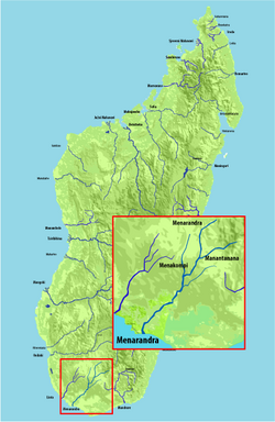
Menarandra is a river in the regions of Androy and Atsimo-Andrefana in southern Madagascar. It flows into the Indian Ocean near Bevoalavo Est.
Its annual discharge is low, approx. 2-3 L/s/km at Tranoroa where it also crossed the National road 10. Between Tranoroa and its mouth in the Indian Ocean it forms the border between the regions of Androy and Atsimo-Andrefana.
References
This article related to a river in Madagascar is a stub. You can help Misplaced Pages by expanding it. |