| This article does not cite any sources. Please help improve this article by adding citations to reliable sources. Unsourced material may be challenged and removed. Find sources: "Linta River" – news · newspapers · books · scholar · JSTOR (September 2017) (Learn how and when to remove this message) |
| Linta River | |
|---|---|
 Linta river Linta river | |
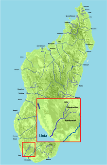
 Map of Malagasy rivers (Linta flows into the Indian Ocean). Map of Malagasy rivers (Linta flows into the Indian Ocean). | |
| Location | |
| Country | Madagascar |
| Region | Atsimo-Andrefana |
| City | Ejeda |
| Physical characteristics | |
| Source | |
| • elevation | 520 m (1,710 ft) |
| Source confluence | Fotadrevo |
| Mouth | Indian Ocean |
| • location | Androka, Atsimo-Andrefana |
| • coordinates | 25°02′00″S 44°01′00″E / 25.03333°S 44.01667°E / -25.03333; 44.01667 |
| • elevation | 0 m (0 ft) |
| Length | 173 km (107 mi) |
| Basin size | 5,800 km (2,200 sq mi) |
| Basin features | |
| Tributaries | |
| • left | Manakaralahy, Manakaravavy |
Linta is a river in the region of Atsimo-Andrefana in southern Madagascar. It crosses the Route nationale 10 near Ejeda and flows into the Indian Ocean in the Bay of Langarano, east of Androka.
Its main affluents are the Manakaralahy and Manakaravavy which are dry during the dry season from July to November. Its annual discharge is low, approx. 1-2 L/s/km.
References
This article related to a river in Madagascar is a stub. You can help Misplaced Pages by expanding it. |