| This article needs additional citations for verification. Please help improve this article by adding citations to reliable sources. Unsourced material may be challenged and removed. Find sources: "Nea Kameni" – news · newspapers · books · scholar · JSTOR (May 2009) (Learn how and when to remove this message) |
| Nea Kameni | |
|---|---|
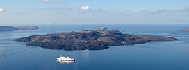
 Nea Kameni seen from Thera, Santorini Nea Kameni seen from Thera, Santorini | |
| Highest point | |
| Elevation | 114 m (374 ft) |
| Coordinates | 36°24′N 25°24′E / 36.400°N 25.400°E / 36.400; 25.400 |
| Geography | |
| Location | Santorini, Greece |
| Geology | |
| Mountain type | Lava dome |
| Volcanic arc | South Aegean Volcanic Arc |
| Last eruption | 1950 |
Nea Kameni is a small, uninhabited Greek island of volcanic origin located in the Aegean Sea, within the flooded Santorini caldera. Nea Kameni (new burnt) and the neighbouring small island Palea Kameni (old burnt) have formed over the past two millennia through repeated eruptions of dacite lava and ash. The Roman historian Cassius Dio records in the year 47 CE "This year a small islet, hitherto unknown, made an appearance close to the island of Thera." Cassius' report may refer to Palaia Kameni. Pliny the Elder reports a new island emerging on July 8, in the year of the consulship of M. Junius Silanus and L. Balbus, thus 19 CE.
Major eruptions over the past 300 years took place in 1707–1712, 1866–1870, 1925–1928, and 1939–1941. The last small eruption happened in 1950 and involved lava dome extrusion.
Nea Kameni is nearly round, and has a diameter of approximately 2 kilometers and an area of 3.4 km. It is monitored closely by scientists from the Institute for the Study and Monitoring of the Santorini Volcano (ISMOSAV), and is a protected scientific site. The island has many vents, one of which is an active sulfur vent, named Jorgo (George), as well as a carpet of red grassy succulents on the thin soil in the summertime. The active vent was named by the locals after King George I of Greece, as the vent was active the day after the King visited Santorini.
The nearly barren island is visited daily by dozens of tourist boats throughout the summer. Visitors climb a gravel path to reach the top of the 130-meter-high volcanic crater, where it is possible to complete a full circuit of the rim.
 |
 |
 |
References
- "Global Volcanism Program | Santorini | Synonyms and Subfeatures". Volcano.si.edu. Retrieved 2012-03-04.
- Dio's Roman History, Epitome of Book LXI.7.
- Pliny. Naturalis Historia. Vol. 4.12.23.
- "Global Volcanism Program | Santorini | Eruptive History". Volcano.si.edu. Retrieved 2012-03-04.
- Institute for the Study and Monitoring of the Santorini Volcano Archived 2009-04-13 at the Wayback Machine Retrieved 2009-05-17
External links
- Nea Kameni Virtual Tour, Volcano 360 Panorama Virtual Tour in High Resolution *Dead link*
| Islands of the Cyclades | |
|---|---|
| Main | |
| Other | |
| Uninhabited |
|
| Greek islands: Aegean Islands, Saronic Islands, Crete, Cyclades, Dodecanese, Euboea, North Aegean Islands, Sporades, Ionian Islands, Echinades | |
