| Native name: Περιστερόβραχοι | |
|---|---|
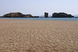
 The islets/rocks of Peristerovrachi. The islets/rocks of Peristerovrachi. | |
| Geography | |
| Coordinates | 35°15′21″N 26°16′01″E / 35.25583°N 26.26694°E / 35.25583; 26.26694 |
| Archipelago | Cretan Islands |
| Administration | |
| Greece | |
| Region | Crete |
| Regional unit | Lasithi |
| Demographics | |
| Population | 0 (2001) |
Peristerovrachoi (Greek: Περιστερόβραχοι, lit. 'pigeon rocks'), are uninhabited Greek islets/rocks, in the Aegean Sea, close to the eastern coast of Crete. Administratively they lie within the Itanos municipality of Lasithi.
See also
References
- "Peristerovrachoi". Peristerovrachoi. Retrieved 2023-11-21.
- Τουρούτογλου, Αναστασία (2022-06-14). "Φοινικόδασος Βάι: Ένα εξωτικό θαύμα στο ανατολικό άκρο της Κρήτης". travel.gr (in Greek). Retrieved 2023-11-21.
| Cretan islands | |||||
|---|---|---|---|---|---|
| Chania regional unit |
| ||||
| Rethymno regional unit |
| ||||
| Heraklion regional unit |
| ||||
| Lasithi regional unit |
| ||||
| Greek islands: Aegean Islands, Saronic Islands, Crete, Cyclades, Dodecanese, Euboea, North Aegean Islands, Sporades, Ionian Islands, Echinades | |||||
This Crete location article is a stub. You can help Misplaced Pages by expanding it. |
