| Line 2 | |
|---|---|
 | |
| Overview | |
| Native name | 2호선(二號線) I Hoseon |
| Status | Operational |
| Termini | |
| Stations | 51 |
| Service | |
| Type | Rapid transit |
| System | Seoul Metropolitan Subway |
| Operator(s) | Seoul Metro |
| History | |
| Opened | October 31, 1980 (1980-10-31) |
| Technical | |
| Line length | 60.2 km (37.4 mi) |
| Number of tracks | 2 |
| Electrification | 1,500 V DC overhead catenary |
| Operating speed | 90 km/h (56 mph) |
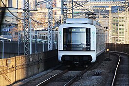
Seoul Subway Line 2 (Korean: 서울 지하철 2호선), also known as the Circle Line, is a circular line of the Seoul Metropolitan Subway. The line running clockwise is called the "inner circle line" and the counter-clockwise line is called the "outer circle line". This is Seoul's most heavily used line, and consists of the main loop (48.8 km (30.3 mi)), the Seongsu Branch (5.4 km (3.4 mi)) and the Sinjeong Branch (6.0 km (3.7 mi)) for a total line length of 60.2 km (37.4 mi). The Line 2 loop is the third longest subway loop in the world after Moscow Metro Bolshaya Koltsevaya line and Beijing Subway Line 10. In 2019, Line 2 had an annual ridership of 812 million passengers or 2.2 million passengers per day.
Headways on the line vary from 2 minutes 18 seconds on peak periods and 5–6 minutes off-peak periods. The line connects the city centre to Gangnam, Teheran Valley and the COEX/KWTC complex.
History
| This section needs additional citations for verification. Please help improve this article by adding citations to reliable sources in this section. Unsourced material may be challenged and removed. (July 2024) (Learn how and when to remove this message) |


In 1972, then-Mayor of Seoul Koo Ja-choon [ko] (1932–1996) changed the existing plans for the Seoul Subway to better enable connectivity around the growing Seoul City and allow for development to take place across the Seoul Capital Area. Line 2 was built in 1978–84 together with the Seongsu Branch (the second Sinjeong Branch was built 1989–95). Dangsan bridge was closed for reconstruction in 1996 and reopened November 22, 1999. The old steel girder bridge was replaced by a 1.3-kilometre (0.81 mi) long concrete bridge between Dangsan on the southern side of the river and Hapjeong on the northern bank.
Yongdu station on the Seongsu Branch (between Sindap and Sinseol stations) is the first station in the Seoul Subway system with operating platform screen doors. As of 2008 platform screen doors are operating at all stations along Line 2. New rolling stock has also progressively came on line, replacing older vehicles.
- October 31, 1980: Sinseol-dong – Sports Complex (via Seongsu) section opened
- December 23, 1982: Sports Complex – Seoul Nat'l Univ. of Education section opened
- September 16, 1983: Euljiro 1-ga – Seongsu section opened; Sinseol-dong – Seongsu section separated as Seongsu Branch
- December 17, 1983: Seoul Nat'l Univ. of Education – Seoul Nat'l University section opened
- May 22, 1984: Seoul Nat'l University – Euljiro 1-ga (via Sindorim) section opened; the Circle Line (the longest in the world at 54.2 km (33.7 mi) until it was surpassed in 2013) is completed.
- May 22, 1992: Sindorim – Yangcheon-gu Office section opened as Sinjeong Branch
- February 29, 1996: Sinjeongnegeori Station opened as extension of Sinjeong Branch
- March 20, 1996: Kkachisan Station opened as extension of Sinjeong Branch
- October 20, 2005: Yongdu Station opened on the Seongsu Branch
- September 2010: Siemens Mobility ATP/ATO GoA 2 signalling system implemented on newer trains to increase frequencies and route capacity.
Facilities
In December 2010 the line is recorded as having the highest WiFi data consumption in the Seoul Metropolitan area. It averaged 2.56 times more than the other 14 subway lines fitted with WiFi service zones.
In 2011, retailer Homeplus opened the world's first virtual supermarket at Seolleung station, where smartphone users can photograph the bar code of life-size pictures, on the walls and platform screen doors, of 500 items of food, toiletries, electronics etc., for delivery within the same day.
Stations
All stations on all branches are in Seoul.
Main Line
Seongsu Branch
| Station Number |
Station Name English |
Station Name Hangul |
Station Name Hanja |
Transfer | Distance in km |
Total Distance |
Location | ||
|---|---|---|---|---|---|---|---|---|---|
| 211 | Seongsu | 성수 | 聖水 | --- | 0.0 | Seongdong-gu | |||
| 211-1 | Yongdap | 용답 | 龍踏 | 2.3 | 2.3 | ||||
| 211-2 | Sindap | 신답 | 新踏 | 1.0 | 3.3 | ||||
| 211-3 | Yongdu (Dongdaemun-gu Office) |
용두 (동대문구청) |
龍頭 (東大門區廳) |
0.9 | 4.2 | Dongdaemun-gu | |||
| 211-4 | Sinseol-dong | 신설동 | 新設洞 | 1.2 | 5.4 | ||||
Sinjeong Branch
| Station Number |
Station Name English |
Station Name Hangul |
Station Name Hanja |
Transfer | Distance in km |
Total Distance |
Location | ||
|---|---|---|---|---|---|---|---|---|---|
| 234 | Sindorim | 신도림 | 新道林 | --- | 0.0 | Guro-gu | |||
| 234-1 | Dorimcheon | 도림천 | 道林川 | 1.0 | 1.0 | ||||
| 234-2 | Yangcheon-gu Office | 양천구청 | 陽川區廳 | 1.7 | 2.7 | Yangcheon-gu | |||
| 234-3 | Sinjeongnegeori | 신정네거리 | 新亭네거리 | 1.9 | 4.6 | ||||
| 234-4 | Kkachisan | 까치산 | 까치山 | 1.4 | 6.0 | Gangseo-gu | |||
Extension
There is a possible extension currently in the conception stage to extend the Sinjeong Branch to 3.7 km to Gayang Station on Line 9. The path would include a new station named Gangseo-gu Office in between Kkachisan and Gayang.
Route map
Rolling stock

Five generations of Seoul Metro 2000 series trains have been used on Seoul Subway Line 2. As of January 2025, only third, fourth and fifth batch 2000 series trains are in operation (manufactured by Hyundai Rotem and Dawonsys respectively), since all first (MELCO thyristor chopper control) and second batch (GEC Traction/Alstom thyristor chopper control) trains have been retired between 2008 and 2023. All trains are stored and maintained at Sindap Depot on the Seongsu Branch and Sinjeong Depot on the Sinjeong Branch.
See also
Notes
- As of January ‹See RfD› 2025, Seoul Subway Line 2 is the third longest rapid transit loop line after Line 10 of Beijing Subway and Bolshaya Koltsevaya line of Moscow Metro. When accounting for total distance (+ both branch lines), Seoul Subway Line 2 is the second-longest, only losing out to Bolshaya Koltsevaya line by 1.5 km (0.93 mi).
References
- "Moscow Metro launches World's longest metro circle line - Big Circle Line 11". Metro Rail. Retrieved March 1, 2023.
- "Beijing Subway Line 10: "If you like it then you should have put a ring round it"". December 9, 2012.
- "서울시 지하철수송 통계". data.seoul.go.kr (in Korean). Retrieved May 21, 2021.
- [사회]서울 지하철2호선 출근길 배차간격 12초 짧아져. Ytn.co.kr (2010-11-22). Retrieved on 2013-07-12.
- "개요 및 연혁" [Overview and History]. seoulmetro.co.kr (in Korean). Archived from the original on February 5, 2024. Retrieved July 12, 2024.
- "Seoul Subway Line No. 2 Becomes Major WiFi Hotspot". The Chosun Ilbo. December 24, 2010. Retrieved April 25, 2012.
- Murthy, Rishika (September 22, 2011). "Seoul's 6 coolest subway stops". CNN Travel. Retrieved February 26, 2013.
- Han, Woojin (February 1, 2012). "서울지하철 2호선 신정지선 연장" (Korean Language). 미래 철도 DB. Retrieved December 9, 2012.
External links
| Railways |
| ||||||||||||||||
|---|---|---|---|---|---|---|---|---|---|---|---|---|---|---|---|---|---|
| Roads |
| ||||||||||||||||
| Buses |
| ||||||||||||||||
| Airports | |||||||||||||||||
| Related topics | |||||||||||||||||
| Seoul Capital Area |
| ||||||||||||||||
|---|---|---|---|---|---|---|---|---|---|---|---|---|---|---|---|---|---|
| Busan |
| ||||||||||||||||
| Daegu |
| ||||||||||||||||
| Gwangju | |||||||||||||||||
| Daejeon | |||||||||||||||||
| Italics : Under construction | |||||||||||||||||
37°33′22″N 126°56′24″E / 37.556°N 126.940°E / 37.556; 126.940
Categories: