Misplaced Pages

Wenceslau Braz, Minas Gerais

Article snapshot taken from Wikipedia with creative commons attribution-sharealike license. Give it a read and then ask your questions in the chat. We can research this topic together.
Not to be confused with Wenceslau Braz, Paraná. Municipality in Southeast, Brazil
Wenceslau Braz
Municipality
Municipality of Wenceslau Braz
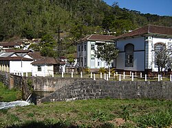
View of Wenceslau BrazView of Wenceslau Braz
Official seal of Wenceslau BrazSeal
Location in Minas GeraisLocation in Minas Gerais
Wenceslau Braz is located in BrazilWenceslau BrazWenceslau BrazLocation in Brazil
Coordinates: 22°32′02″S 45°21′46″W / 22.53389°S 45.36278°W / -22.53389; -45.36278
Country Brazil
RegionSoutheast
State Minas Gerais
FoundedDecember 30, 1962
Area
 • Total102.487 km (39.570 sq mi)
Elevation1,005 m (3,297 ft)
Population
 • Total2,548
Time zoneUTC−3 (BRT)
Postal code37512-000
Area code35
Websitewenceslaubraz.mg.gov.br

Wenceslau Braz is a Brazilian municipality in the state of Minas Gerais. As of 2020, its population was estimated to be 2,548.

History

Hydroelectric plant

Between 1922 and 1932, German engineers constructed a 3.4 MW hydroelectric power station (Hidrelétrica Bicas do Meio) for the Itajubá Piquete power grid company (REPI). Two transmission lines, mounted on steel lattice poles, supplied energy to the towns of Piquete and Itajubá and nearby weapon manufacturers.

References

  1. "Área dos municípios" [Area of the municipalities] (in Portuguese). Brazilian Institute of Geography and Statistics(IBGE). Retrieved 2018-04-17.
  2. IBGE 2020
  3. Prefeitura de Wenceslau Braz - MG - Sobre a Cidade
Municipalities of Minas Gerais
Capital: Belo Horizonte
Intermediate Geographic Region of Barbacena
Barbacena
Conselheiro Lafaiete
São João del-Rei
Intermediate Geographic Region of Belo Horizonte
Belo Horizonte
Sete Lagoas
Santa Bárbara-Ouro Preto
Curvelo
Itabira
Intermediate Geographic Region of Divinópolis
Divinópolis
Formiga
Dores do Indaiá
Pará de Minas
Oliveira
Abaeté
Intermediate Geographic Region of Governador Valadares
Governador Valadares
Guanhães
Mantena
Aimorés-Resplendor
Intermediate Geographic Region of Ipatinga
Ipatinga
Caratinga
João Monlevade
Intermediate Geographic Region of Juiz de Fora
Juiz de Fora
Manhuaçu
Ubá
Ponte Nova
Muriaé
Cataguases
Viçosa
Carangola
São João Nepomuceno-Bicas
Além Paraíba
Intermediate Geographic Region of Montes Claros
Montes Claros
Janaúba
Salinas
Januária
Pirapora
São Francisco
Espinosa
Intermediate Geographic Region of Patos de Minas
Patos de Minas
Unaí
Patrocínio
Intermediate Geographic Region of Pouso Alegre
Pouso Alegre
Poços de Caldas
Itajubá
São Lourenço
Caxambu-Baependi
Intermediate Geographic Region of Teófilo Otoni
Capelinha
Teófilo Otoni
Almenara
Diamantina
Araçuaí
Pedra Azul
Águas Formosas
Intermediate Geographic Region of Uberaba
Uberaba
Araxá
Frutal
Iturama
Intermediate Geographic Region of Uberlândia
Uberlândia
Ituiutaba
Monte Carmelo
Intermediate Geographic Region of Varginha
Varginha
Passos
Alfenas
Lavras
Guaxupé
Três Corações
Três Pontas-Boa Esperança
São Sebastião do Paraíso
Campo Belo
Piumhi
Stub icon

This geographical article relating to Minas Gerais is a stub. You can help Misplaced Pages by expanding it.

Categories: