| Revision as of 12:40, 27 May 2024 editEnfantDeLaVille (talk | contribs)Extended confirmed users667 editsNo edit summaryTag: Visual edit← Previous edit | Latest revision as of 16:47, 4 November 2024 edit undo185.81.141.57 (talk)No edit summaryTags: Visual edit Mobile edit Mobile web edit | ||
| (7 intermediate revisions by 5 users not shown) | |||
| Line 123: | Line 123: | ||
| }} | }} | ||
| '''Batroun District''' ({{ |
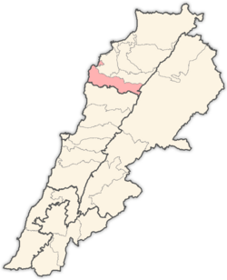
'''Batroun District''' ({{langx|ar|البترون}}) is a district ('']'') located in the ], ], south of ]. Its capital is the city of ], which is one of the ]. Its natural borders are: in the south the ] and in the north the Madfoun river. | ||
| The region is known for its vineyards located at an altitude of 1,300 meters, which helps grow high-quality grapes that are used to make wines that are intense in color and full of flavor.<ref>{{Cite web |title=Your 2024 guide to Batroun wine region |url=https://www.winetourism.com/wine-region/batroun/ |access-date=2024-05-27 |website=www.winetourism.com |language=en-US}}</ref> ] | The region is known for its vineyards located at an altitude of 1,300 meters, which helps grow high-quality grapes that are used to make wines that are intense in color and full of flavor.<ref>{{Cite web |title=Your 2024 guide to Batroun wine region |url=https://www.winetourism.com/wine-region/batroun/ |access-date=2024-05-27 |website=www.winetourism.com |language=en-US}}</ref> ] | ||
| ==Demographics== | |||
| As of 2022, the religious make-up of the District's 62,444 voters were roughly 70% ], 17% ], 7% ], 3% ], 2% other ] and 1% Others.<ref>{{Cite web |title=Mapping Lebanon: Data and statistics |url=https://www.lorientlejour.com/article/1297803/data-and-statistics.html}}</ref> | |||
| {{Pie chart | |||
| | thumb = Religion in the Batroun District | |||
| | label1 = ] | |||
| | value1 = 70 | |||
| | color1 = #CBC3E3 | |||
| | label2 = ] | |||
| | value2 = 17 | |||
| | color2 = #ADD8E6 | |||
| | label3 = ] | |||
| | value3 = 7 | |||
| | color3 = #90EE90 | |||
| | label4 = ] | |||
| | value4 = 3 | |||
| | color4 = #FF7F7F | |||
| | label5 = ] | |||
| | value5 = 2 | |||
| | color5 = #FFFFC5 | |||
| | label6 = Others | |||
| | value6 = 1 | |||
| | color6 = #D3D3D3 | |||
| }} | |||
| ==Cities and towns== | ==Cities and towns== | ||
| * ] | * ] | ||
| Line 200: | Line 226: | ||
| ==Sources== | ==Sources== | ||
| * | |||
| ⚫ | ==References== | ||
| {{reflist}} | |||
| ⚫ | == |
||
| {{Batroun District}} | {{Batroun District}} | ||
Latest revision as of 16:47, 4 November 2024
District in North Governorate, Lebanon| Batroun District | |
|---|---|
| District | |
| البترون | |
 Tannurin El Fawqa, Batroun District Tannurin El Fawqa, Batroun District | |
| Nickname: Fadous | |
 Location in Lebanon Location in Lebanon | |
| Country | |
| Governorate | North Governorate |
| Capital | Batroun |
| Area | |
| • Total | 111 sq mi (287 km) |
| Population | |
| • Estimate | 57,339 |
| Time zone | UTC+2 (EET) |
| • Summer (DST) | UTC+3 (EEST) |
Batroun District (Arabic: البترون) is a district (qadaa) located in the North Governorate, Lebanon, south of Tripoli. Its capital is the city of Batroun, which is one of the oldest continuously inhabited cities in the world. Its natural borders are: in the south the El Jaouz river and in the north the Madfoun river.
The region is known for its vineyards located at an altitude of 1,300 meters, which helps grow high-quality grapes that are used to make wines that are intense in color and full of flavor.

Demographics
As of 2022, the religious make-up of the District's 62,444 voters were roughly 70% Maronite Catholics, 17% Greek Orthodox, 7% Sunni, 3% Greek Catholic, 2% other Shia and 1% Others.
Maronite Catholics (70%) Greek Orthodox (17%) Sunni (7%) Greek Catholic (3%) Shia (2%) Others (1%)Cities and towns
- Aabdelli
- Aabrine
- Aalali
- Aaoura
- Aartiz
- Asia
- Batroun
- Basbina
- Bchaaleh
- Beit Chlala
- Beit Kassab
- Bijdarfil
- Boqsmaiya
- Chatine
- Chekka
- Chibtine
- Daael
- Dahr Abi Yaghi
- Darya
- Deir Billa
- Douma
- Douq
- Eddeh
- Ftahat
- Ghouma
- Hadtoun
- Hamat
- Harbouna
- Hardine
- Heri
- Hilta
- Ijdabra
- Jebla
- Jrabta
- Jran
- Kandoula
- Fadous
- Kfar Chleymane
- Kfar Hatna
- Kfar Hay
- Kfar Hilda
- Kfar Shlaimane
- Kfifane
- Kfour El Arabi
- Koubba
- Kour
- Madfoun
- Mehmarch
- Mar Mama
- Masrah
- Mrah Chdid
- Mrah Ez Ziyat
- Nahla
- Niha, Batroun
- Ouajh El Hajar
- Ouata Houb
- Qandola
- Racha
- Rachana
- Rachkida
- Ram, Batroun
- Ras Nahhach
- Selaata
- Sghar
- Smar Jbeil
- Sourat
- Tannourine El Faouqa
- Thoum
- Toula
- Wata Hob
- Zane
Sources
References
- "Your 2024 guide to Batroun wine region". www.winetourism.com. Retrieved 2024-05-27.
- "Mapping Lebanon: Data and statistics".
34°15′N 35°39′E / 34.250°N 35.650°E / 34.250; 35.650
This Lebanon location article is a stub. You can help Misplaced Pages by expanding it. |
