Commune in Normandy, France
| Le Bec-Hellouin | |
|---|---|
| Commune | |
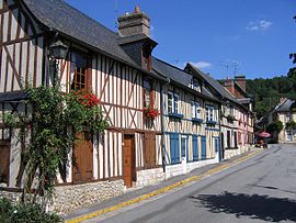
 Houses in Le Bec-Hellouin Houses in Le Bec-Hellouin | |
 Coat of arms Coat of arms | |
| Location of Le Bec-Hellouin | |
  | |
| Coordinates: 49°13′57″N 0°43′18″E / 49.2325°N 0.7217°E / 49.2325; 0.7217 | |
| Country | France |
| Region | Normandy |
| Department | Eure |
| Arrondissement | Bernay |
| Canton | Brionne |
| Intercommunality | Bernay Terres de Normandie |
| Government | |
| • Mayor (2020–2026) | Pascal Finet |
| Area | 9.55 km (3.69 sq mi) |
| Population | 378 |
| • Density | 40/km (100/sq mi) |
| Time zone | UTC+01:00 (CET) |
| • Summer (DST) | UTC+02:00 (CEST) |
| INSEE/Postal code | 27052 /27800 |
| Elevation | 46–141 m (151–463 ft) |
| French Land Register data, which excludes lakes, ponds, glaciers > 1 km (0.386 sq mi or 247 acres) and river estuaries. | |
Le Bec-Hellouin (French pronunciation: [lə bɛk ɛlwɛ̃]) is a commune in the department of Eure in the Normandy region in northern France.
It is best known for Bec Abbey and has recently been voted one of the "most beautiful villages of France". The current mayor is Pascal Finet who replaced Jean-Paul Vittecoq in 2014.
Geography
The commune along with another 69 communes shares part of a 4,747 hectare, Natura 2000 conservation area, called Risle, Guiel, Charentonne.
History
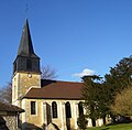
Bec Abbey was founded in 1034 by Herluin, who was a knight at the court of Brionne and a Benedictine. Near to the abbey, in the village, the church, dedicated to Saint-André, was built in 1039. The original church burned down in 1264. It was rebuilt but damaged during the Hundred Years' War (1417). The nave and the bell tower were reconstructed in the 18th century.
In 1791 the abbey was closed because of the French Revolution and the departing monks transferred many statues to the village church; even the tomb of Herluin was moved to the church in 1792. From 1792 to 1794 bells and valuable decorative objects were removed from the church and finally brought to Bernay.
The windows of the church were destroyed during the bombing of Le Bec-Hellouin on 13 August 1944, in the course of World War II. The new windows were made in 1959. The Benedictine monks returned in 1948 and the tomb of Herluin was moved back to the abbey in 1959.

Etymology
Known as Beccensis Ecclesia in 1041 and in Beccus Herlevini 1160. The village takes its name from the Scandinavian word for creek mouth (bekkr). While Hellouin refers to Blessed Herluin, founder of the nearby abbey. whose name is of Germanic origin.
Notable people
Arnost, bishop of Rochester, England, 1076
Landmarks
- Abbey of Bec-Hellouin.
- Monastery of Saint Francesca Romana
- St. Andrew's Church
- The village has a set of typical half-timbered houses, grouped around the Abbey Our Lady of Bec.
-
 Map of Le Bec-Hellouin
-
 Town hall
-
 Rue du Quartier Burcy in the village of Le Bec-Hellouin
-
 Half-timbered houses
-
 Church of St Andrews
-
 Church of St Andrews from the east
-
 Church in abbaye Notre-Dame du Bec
-
 Bec Abbey
-
 Bec Abbey
-
 West side of the Tour Saint-Nicolas, between the ancient pottery to its left and the monks' residential building to its right
-
 Southern façade of the abbey
-
 The cloister
-
 Bec Abbey Library
Population
|
| ||||||||||||||||||||||||||||||||||||||||||||||||||||||||||||||||||||||||||||||||||||||||||||||||||||||||||||||||||
| |||||||||||||||||||||||||||||||||||||||||||||||||||||||||||||||||||||||||||||||||||||||||||||||||||||||||||||||||||
| Source: EHESS and INSEE (1968-2017) | |||||||||||||||||||||||||||||||||||||||||||||||||||||||||||||||||||||||||||||||||||||||||||||||||||||||||||||||||||
Further reading
- Dannenberg, Linda; Pierre Levec; Pierre Moulin (1989). Pierre Deux's Normandy. Oxford: Phaidon Press. pp. 56–61. ISBN 0-7148-2576-X.
See also
References

- "Répertoire national des élus: les maires" (in French). data.gouv.fr, Plateforme ouverte des données publiques françaises. 13 September 2022.
- "Populations de référence 2022" (in French). The National Institute of Statistics and Economic Studies. 19 December 2024.
- "INPN - FSD Natura 2000 - FR2300150 - Risle, Guiel, Charentonne - Description".
- Toponymie générale de la France, Volume 2, Ernest Nègre page 1011.
- François de Beaurepaire (préf. Marcel Baudot), Les Noms des communes et anciennes paroisses de l'Eure, (Paris, A. et J. Picard, 1981), p.221.
- Des villages de Cassini aux communes d'aujourd'hui: Commune data sheet Le Bec-Hellouin, EHESS (in French).
- Population en historique depuis 1968, INSEE