 R497 road
 | |
|---|---|
| Bóthar R497 | |
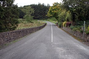
 R497 leaving Milestone towards Hollyford R497 leaving Milestone towards Hollyford | |
| Route information | |
| Length | 57 km (35 mi) |
| Location | |
| Country | Ireland |
| Primary destinations |
|
| Highway system | |
The R497 road is a regional road in Ireland which runs north-south from Nenagh, County Tipperary to the N24 in Tipperary Town.
The entire route is in County Tipperary and is 57 km (35 mi) long. Part of the road is known as the Anglesey Road, named after the Marquis of Anglesey who gave orders to have it built.
Just north of the village of Hollyford the road passes through Anglesey Road special area of conservation (site reference code 002125), a small site containing a variety of habitats and species found in unimproved upland grassland within the steep valley of the Multeen, a tributary of the River Suir. The main threat to the site is agricultural improvement and afforestation.
See also
References
- "Upperchurch Drombane - News Upperchurch". Archived from the original on 2 July 2013. Retrieved 23 April 2013.
- "Special Areas of Conservation (SAC)". National Parks & Wildlife Service.